
– Lat/Long: 49.58° S 69.50° E
 Mont Ross
Weather Forecast, French Southern and Antarctic LandsIssued: 10 am Fri 25 Apr Local TimeUpdates in: hr min sUpdate imminent
Mont Ross Weather Forecast, French Southern and Antarctic Lands
Issued: 10 am Fri 25 Apr Local Time
Updates in:
Update imminent hr min s

Issued: 10 am Fri 25 Apr Local Time
Updates in:
Update imminent hr min s
Days 1–3 Weather SummaryModerate rain (total 13mm), heaviest on Fri morning. Mild temperatures (max 7°C on Sat afternoon, min 3°C on Fri afternoon). Winds decreasing (gales from the NNW on Sat afternoon, fresh winds from the W by Sun night). | Days 4–6 Weather SummaryModerate rain (total 17mm), heaviest on Mon afternoon. Mild temperatures (max 8°C on Wed afternoon, min 3°C on Mon afternoon). Winds increasing (light winds from the WNW on Mon morning, severe gales from the WSW by Wed night). | |||||||||||||||||
Friday 25 | Saturday 26 | Sunday 27 | Monday 28 | Tuesday 29 | Wednesday 30 | |||||||||||||
AM | PM | night | AM | PM | night | AM | PM | night | AM | PM | night | AM | PM | night | AM | PM | night | |
rain shwrs | rain shwrs | rain shwrs | light rain | light rain | rain shwrs | rain shwrs | rain shwrs | rain shwrs | light rain | mod. rain | rain shwrs | light rain | light rain | light rain | light rain | rain shwrs | rain shwrs | |
km/h | ||||||||||||||||||
 |  |  |  |  |  | |||||||||||||
— | — | — | — | — | — | — | — | — | — | — | — | — | — | — | — | — | — | |
4 | 0.5 | 0.3 | 0.1 | 4 | 2 | 0.1 | 0.2 | 0.9 | 0.7 | 5 | 1.9 | 0.6 | 2.0 | 5 | 0.6 | 0.2 | 0.9 | |
max°C | 4 | 3 | 5 | 6 | 7 | 6 | 4 | 4 | 5 | 5 | 4 | 5 | 4 | 7 | 7 | 6 | 8 | 8 |
min°C | 4 | 3 | 3 | 5 | 6 | 4 | 4 | 4 | 4 | 4 | 3 | 3 | 4 | 6 | 6 | 6 | 7 | 5 |
-2 | -5 | -4 | -2 | -1 | -3 | -3 | -3 | -2 | -1 | -2 | -3 | -3 | -1 | 0 | 0 | 1 | -2 | |
500 | 400 | 500 | 750 | 1350 | 450 | 400 | 500 | 600 | 700 | 550 | 500 | 1350 | 2200 | 2050 | 2700 | 2950 | 1000 | |
Cloud base (m) | 250 | 450 | 700 | 450 | 150 | 300 | 400 | 450 | 200 | 200 | 200 | 250 | 300 | 200 | 200 | 250 | 200 | 250 |
7:18 | — | — | 7:18 | — | — | 7:20 | — | — | 7:22 | — | — | 7:24 | — | — | 7:24 | — | — | |
— | 5:21 | — | — | 5:19 | — | — | 5:16 | — | — | 5:15 | — | — | 5:13 | — | — | 5:12 | — | |
Loading...
Mont Ross Weather (Days 0-3):
The weather forecast for Mont Ross is: Moderate rain (total 13mm), heaviest on Fri morning. Mild temperatures (max 7°C on Sat afternoon, min 3°C on Fri afternoon). Winds decreasing (gales from the NNW on Sat afternoon, fresh winds from the W by Sun night).
Mont Ross Weather (Days 3-6):
Moderate rain (total 17mm), heaviest on Mon afternoon. Mild temperatures (max 8°C on Wed afternoon, min 3°C on Mon afternoon). Winds increasing (light winds from the WNW on Mon morning, severe gales from the WSW by Wed night).
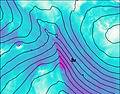
This table gives the weather forecast for Mont Ross at the specific elevation of 0 m. Our advanced weather models allow us to provide distinct weather forecasts for several elevations of Mont Ross. To see the weather forecasts for the other elevations, use the tab navigation above the table. For a wider overview of the weather, consult the Weather Map of French Southern and Antarctic Lands.

