– Lat/Long: 42.80° N 1.09° E
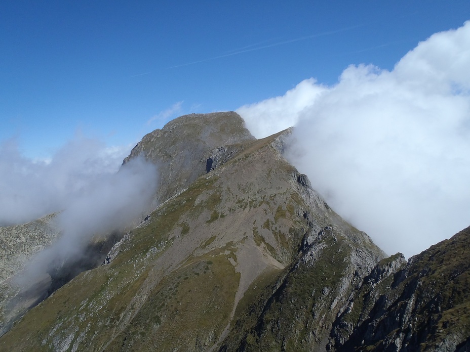
 Mont Valier
Weather Forecast, FranceIssued: 1 pm Sat 19 Apr Local TimeUpdates in: hr min sUpdate imminent
Mont Valier Weather Forecast, France
Issued: 1 pm Sat 19 Apr Local Time
Updates in:
Update imminent hr min s

Issued: 1 pm Sat 19 Apr Local Time
Updates in:
Update imminent hr min s
Days 1–4 Weather SummaryMild with light rain (total 9mm) on Sat afternoon Becoming colder with a light covering of snow, mostly falling on Sat afternoon. Freeze-thaw conditions (max 5°C on Sun afternoon, min -1°C on Sat night). Wind will be generally light. | Days 5–7 Weather SummaryLight rain (total 4mm), mostly falling on Tue night. Very mild (max 10°C on Thu afternoon, min 2°C on Wed morning). Wind will be generally light. | ||||||||||||||||
Sat 19 | Sunday 20 | Monday 21 | Tuesday 22 | Wednesday 23 | Thursday 24 | ||||||||||||
PM | night | AM | PM | night | AM | PM | night | AM | PM | night | AM | PM | night | AM | PM | night | |
light snow | snow shwrs | clear | rain shwrs | rain shwrs | rain shwrs | light rain | rain shwrs | cloudy | light rain | light rain | rain shwrs | some clouds | clear | clear | rain shwrs | rain shwrs | |
km/h | |||||||||||||||||
 |  |  |  |  |  | ||||||||||||
4 | 1.0 | — | — | — | — | — | — | — | — | — | — | — | — | — | — | — | |
6 | — | — | 0.8 | 1.5 | 0.5 | 0.4 | 0.1 | — | 0.8 | 3 | 0.1 | — | — | — | 0.1 | 0.4 | |
max°C | 4 | 1 | 3 | 5 | 3 | 4 | 5 | 5 | 5 | 5 | 5 | 3 | 7 | 6 | 8 | 10 | 8 |
min°C | 2 | -1 | -1 | 5 | 2 | 3 | 5 | 3 | 3 | 5 | 3 | 2 | 6 | 4 | 4 | 10 | 6 |
-1 | -5 | -4 | 5 | 2 | 3 | 3 | 3 | 3 | 4 | 1 | 0 | 4 | 2 | 2 | 9 | 5 | |
1800 | 1300 | 1950 | 2100 | 1950 | 2250 | 2250 | 2100 | 2250 | 2300 | 2100 | 2250 | 2550 | 2850 | 3000 | 3100 | 3200 | |
Cloud base (m) | 1850 | 1900 | 1950 | 2100 | 1900 | 1850 | 1900 | 2050 | 1900 | 1900 | 1850 | 1850 | 2450 | 2250 | 6100 | 2500 | 1950 |
— | — | 7:07 | — | — | 7:05 | — | — | 7:03 | — | — | 7:01 | — | — | 7:01 | — | — | |
— | 8:40 | — | — | 8:42 | — | — | 8:44 | — | — | 8:45 | — | — | 8:45 | — | — | 8:46 | |
Loading...
Mont Valier Weather (Days 0-3):
The weather forecast for Mont Valier is: Mild with light rain (total 9mm) on Sat afternoon Becoming colder with a light covering of snow, mostly falling on Sat afternoon. Freeze-thaw conditions (max 5°C on Sun afternoon, min -1°C on Sat night). Wind will be generally light.
Mont Valier Weather (Days 3-6):
Light rain (total 4mm), mostly falling on Tue night. Very mild (max 10°C on Thu afternoon, min 2°C on Wed morning). Wind will be generally light.
This table gives the weather forecast for Mont Valier at the specific elevation of 1500 m. Our advanced weather models allow us to provide distinct weather forecasts for several elevations of Mont Valier. To see the weather forecasts for the other elevations, use the tab navigation above the table. For a wider overview of the weather, consult the Weather Map of France.
| Weather Station | Temp. | Weather | Wind | Gusts | Cloud / Visibility |
|---|---|---|---|---|---|
Saint Girons | |||||
Port Ainé Massís de l'Orri | |||||
lightning 5km E of Mercus-Garrabet | |||||
Cap del Rec | |||||
lightning 4km SSW of Belpech | |||||
lightning 11km NE of Pas de la Casa | |||||
* NOTE: not all weather observatories update at the same frequency which is the reason why some locations may show data from stations that are further away than known closer ones.
Mont Valier Photos
View all
photos (95) |
Pyrenees photos (134) |
photos from mountains in France (280) |
all photos
 Upload new photo
Mont Valier from the south

