
– Lat/Long: 52.33° S 73.40° W
 Monte Burney
Weather Forecast, ChileIssued: 2 am Wed 02 Apr Local TimeUpdates in: hr min sUpdate imminent
Monte Burney Weather Forecast, Chile
Issued: 2 am Wed 02 Apr Local Time
Updates in:
Update imminent hr min s

Issued: 2 am Wed 02 Apr Local Time
Updates in:
Update imminent hr min s
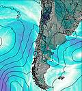
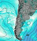
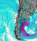
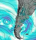
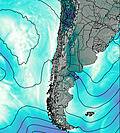
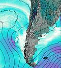
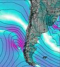
Days 1–3 Weather SummaryLight rain (total 3mm), mostly falling on Fri afternoon. Mild temperatures (max 8°C on Fri night, min 1°C on Thu morning). Wind will be generally light. | Days 4–6 Weather SummaryHeavy rain (total 23mm), heaviest during Mon night. Very mild (max 15°C on Sat afternoon, min 8°C on Sat morning). Winds increasing (light winds from the ENE on Sat afternoon, fresh winds from the NW by Mon afternoon). | Days 7–9 Weather SummaryHeavy rain (total 52mm), heaviest during Wed morning. Very mild (max 11°C on Tue night, min 5°C on Wed morning). Winds increasing (light winds from the WNW on Tue morning, strong winds from the WNW by Wed night). | Days 10–12 Weather SummaryHeavy rain (total 25mm), heaviest during Sun morning. Very mild (max 10°C on Sat afternoon, min 6°C on Sun night). Winds increasing (light winds from the NNW on Fri night, strong winds from the W by Sun afternoon). | |||||||||||||||||||||||||||||||||
Wednesday 2 | Thursday 3 | Friday 4 | Saturday 5 | Sunday 6 | Monday 7 | Tuesday 8 | Wednesday 9 | Thursday 10 | Friday 11 | Saturday 12 | Sunday 13 | |||||||||||||||||||||||||
AM | PM | night | AM | PM | night | AM | PM | night | AM | PM | night | AM | PM | night | AM | PM | night | AM | PM | night | AM | PM | night | AM | PM | night | AM | PM | night | AM | PM | night | AM | PM | night | |
rain shwrs | rain shwrs | clear | clear | clear | some clouds | light rain | light rain | light rain | clear | some clouds | some clouds | some clouds | cloudy | light rain | rain shwrs | light rain | heavy rain | mod. rain | light rain | light rain | heavy rain | mod. rain | rain shwrs | light rain | light rain | light rain | light rain | light rain | light rain | light rain | light rain | light rain | heavy rain | rain shwrs | rain shwrs | |
km/h | ||||||||||||||||||||||||||||||||||||
 |  |  |  |  |  |  |  |  |  |  |  | |||||||||||||||||||||||||
— | — | — | — | — | — | — | — | — | — | — | — | — | — | — | — | — | — | — | — | — | — | — | — | — | — | — | — | — | — | — | — | — | — | — | — | |
0.2 | 0.1 | — | — | — | — | 0.4 | 1.2 | 1.1 | — | — | — | — | — | 3 | 1.2 | 1.9 | 17 | 9 | 3 | 2 | 11 | 6 | 10 | 2 | 4 | 3 | 1.2 | 0.7 | 0.4 | 0.4 | 1.0 | 3 | 12 | 4 | 1.4 | |
max°C | 5 | 6 | 3 | 4 | 7 | 3 | 5 | 6 | 8 | 12 | 15 | 12 | 13 | 15 | 13 | 10 | 10 | 10 | 9 | 10 | 11 | 6 | 6 | 6 | 7 | 8 | 8 | 8 | 9 | 8 | 9 | 10 | 9 | 9 | 7 | 7 |
min°C | 3 | 6 | 2 | 1 | 6 | 2 | 4 | 6 | 6 | 8 | 15 | 11 | 10 | 15 | 9 | 8 | 9 | 9 | 9 | 9 | 8 | 5 | 5 | 6 | 7 | 7 | 8 | 8 | 8 | 8 | 8 | 9 | 9 | 8 | 7 | 6 |
0 | 2 | 2 | 1 | 6 | -1 | 1 | 4 | 4 | 6 | 15 | 11 | 9 | 15 | 6 | 5 | 5 | 6 | 8 | 8 | 5 | 2 | 1 | 2 | 2 | 2 | 4 | 5 | 6 | 6 | 6 | 7 | 7 | 5 | 2 | 1 | |
350 | 600 | 400 | 1150 | 2300 | 2750 | 2000 | 2250 | 2700 | 3000 | 3100 | 3100 | 2950 | 2700 | 2400 | 1100 | 1200 | 1350 | 1300 | 1450 | 1600 | 1000 | 850 | 750 | 900 | 1100 | 1100 | 1050 | 1100 | 1100 | 1200 | 1350 | 1450 | 1300 | 800 | 700 | |
Cloud base (m) | 700 | 750 | 600 | 500 | 450 | 1900 | 800 | 450 | 3800 | 3100 | 4000 | 6150 | 1600 | 400 | 450 | 150 | 150 | 100 | 600 | 150 | 100 | 200 | 250 | 150 | 300 | 150 | 150 | 650 | 2200 | 550 | 150 | 100 | 150 | 450 | ||
8:17 | — | — | 8:18 | — | — | 8:21 | — | — | 8:22 | — | — | 8:23 | — | — | 8:26 | — | — | 8:27 | — | — | 8:29 | — | — | 8:30 | — | — | 8:33 | — | — | 8:33 | — | — | 8:36 | — | — | |
— | 7:35 | — | — | 7:32 | — | — | 7:30 | — | — | 7:28 | — | — | 7:25 | — | — | 7:23 | — | — | 7:21 | — | — | 7:19 | — | — | 7:16 | — | — | 7:15 | — | — | 7:12 | — | — | 7:09 | — | |
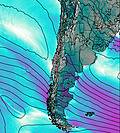
Monte Burney Weather (Days 0-3):
The weather forecast for Monte Burney is: Light rain (total 3mm), mostly falling on Fri afternoon. Mild temperatures (max 8°C on Fri night, min 1°C on Thu morning). Wind will be generally light.
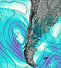
Monte Burney Weather (Days 3-6):
Heavy rain (total 23mm), heaviest during Mon night. Very mild (max 15°C on Sat afternoon, min 8°C on Sat morning). Winds increasing (light winds from the ENE on Sat afternoon, fresh winds from the NW by Mon afternoon).
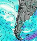
Monte Burney Weather (Days 6-9):
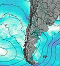
Heavy rain (total 52mm), heaviest during Wed morning. Very mild (max 11°C on Tue night, min 5°C on Wed morning). Winds increasing (light winds from the WNW on Tue morning, strong winds from the WNW by Wed night).
This table gives the weather forecast for Monte Burney at the specific elevation of 0 m. Our advanced weather models allow us to provide distinct weather forecasts for several elevations of Monte Burney. To see the weather forecasts for the other elevations, use the tab navigation above the table. For a wider overview of the weather, consult the Weather Map of Chile.
| Weather Station | Temp. | Weather | Wind | Gusts | Cloud / Visibility |
|---|---|---|---|---|---|
Magallanes Villa Tehuelche | |||||
Punta Arenas Unidad Aeropolicial | |||||
Instituto de la Patagonia (Jorge Schytte) | |||||
ELCalafateAero | |||||
RioGallegosAero | |||||
Rio Gallegos Airport | |||||
Rio Grande Airport | |||||
Ushuaia Naval Base Airport |
* NOTE: not all weather observatories update at the same frequency which is the reason why some locations may show data from stations that are further away than known closer ones.

