– Lat/Long: 45.90° N 68.92° W
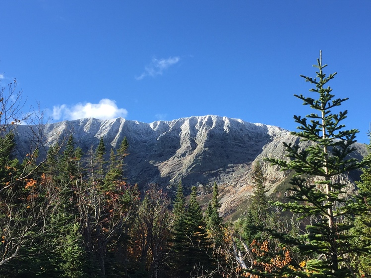
 Mount Katahdin
Weather Forecast, United StatesIssued: 1 am Sat 29 Mar Local TimeUpdates in: hr min sUpdate imminent
Mount Katahdin Weather Forecast, United States
Issued: 1 am Sat 29 Mar Local Time
Updates in:
Update imminent hr min s

Issued: 1 am Sat 29 Mar Local Time
Updates in:
Update imminent hr min s
Days 1–3 Weather SummaryA light covering of new snow mostly falling on Sun afternoon. Becoming milder with light rain (total 3mm) on Mon afternoon. Freeze-thaw conditions (max 10°C on Mon afternoon, min -9°C on Sat morning). Winds increasing (light winds from the SW on Sun morning, gales from the SW by Mon morning). | Days 4–6 Weather SummaryA moderate fall of snow, heaviest on Thu morning. Becoming mild with drizzle, on Thu afternoon. Freeze-thaw conditions (max 6°C on Thu night, min -13°C on Tue night). Winds increasing (light winds from the SSW on Wed afternoon, severe gales from the S by Thu morning). | Days 7–9 Weather SummaryA dusting of new snow. Temperatures will be below freezing (max 0°C on Sat morning, min -12°C on Sun night). Winds decreasing (near gales from the NW on Fri night, light winds from the W by Sat night). | Days 10–12 Weather SummaryA dusting of new snow. Temperatures will be below freezing (max -1°C on Wed afternoon, min -16°C on Mon night). Winds decreasing (gales from the NW on Mon night, moderate winds from the NNW by Wed night). | |||||||||||||||||||||||||||||||||
Saturday 29 | Sunday 30 | Monday 31 | Tuesday 1 | Wednesday 2 | Thursday 3 | Friday 4 | Saturday 5 | Sunday 6 | Monday 7 | Tuesday 8 | Wednesday 9 | |||||||||||||||||||||||||
AM | PM | night | AM | PM | night | AM | PM | night | AM | PM | night | AM | PM | night | AM | PM | night | AM | PM | night | AM | PM | night | AM | PM | night | AM | PM | night | AM | PM | night | AM | PM | night | |
some clouds | clear | some clouds | cloudy | light snow | light snow | light rain | light rain | light rain | cloudy | some clouds | clear | clear | some clouds | light snow | mod. snow | light snow | cloudy | some clouds | some clouds | some clouds | some clouds | cloudy | clear | some clouds | light snow | light snow | cloudy | cloudy | light snow | light snow | cloudy | cloudy | clear | clear | clear | |
km/h | ||||||||||||||||||||||||||||||||||||
 |  |  |  |  |  |  |  |  |  |  |  | |||||||||||||||||||||||||
— | — | — | — | 2.0 | 3 | — | — | — | — | — | — | — | — | 1.0 | 9 | 2.0 | — | — | — | — | — | — | — | — | 1.0 | 2.0 | — | — | 1.0 | 3 | — | — | — | — | — | |
— | — | — | — | — | 0.6 | 0.5 | 1.1 | 0.3 | — | — | — | — | — | — | — | 1.7 | — | — | — | — | — | — | — | — | — | — | — | — | — | — | — | — | — | — | — | |
max°C | -8 | -6 | -7 | -4 | -4 | 5 | 7 | 10 | 7 | -6 | -7 | -12 | -9 | -6 | -5 | -4 | 4 | 6 | -5 | -3 | -2 | 0 | 0 | -2 | -2 | 0 | -3 | -15 | -14 | -12 | -7 | -5 | -5 | -3 | -1 | -4 |
min°C | -9 | -7 | -8 | -6 | -4 | -3 | 6 | 8 | -3 | -8 | -8 | -13 | -11 | -8 | -6 | -6 | -1 | -4 | -5 | -4 | -3 | -3 | 0 | -3 | -3 | -2 | -12 | -15 | -14 | -16 | -9 | -5 | -7 | -4 | -2 | -6 |
-17 | -13 | -12 | -10 | -10 | -10 | -1 | 2 | -12 | -18 | -18 | -24 | -19 | -12 | -11 | -17 | -11 | -14 | -15 | -14 | -13 | -11 | -4 | -7 | -10 | -11 | -24 | -29 | -28 | -31 | -22 | -15 | -17 | -13 | -10 | -14 | |
0 | 300 | 0 | 0 | 0 | 0 | 3050 | 2850 | 1200 | 100 | 150 | 0 | 0 | 350 | 0 | 0 | 2200 | 900 | 450 | 550 | 0 | 900 | 1000 | 0 | 800 | 750 | 0 | 0 | 0 | 0 | 100 | 450 | 0 | 650 | 800 | 0 | |
Cloud base (m) | 6650 | 4500 | 900 | 400 | 350 | 350 | 350 | 400 | 350 | 1400 | 600 | 8150 | 5800 | 2850 | 350 | 350 | 400 | 350 | 350 | 400 | 350 | 700 | 650 | 350 | 300 | 400 | 400 | 600 | 350 | 300 | 450 | 350 | 6200 | 450 | ||
6:22 | — | — | 6:20 | — | — | 6:18 | — | — | 6:16 | — | — | 6:13 | — | — | 6:11 | — | — | 6:09 | — | — | 6:07 | — | — | 6:07 | — | — | 6:05 | — | — | 6:03 | — | — | 6:01 | — | — | |
— | 6:59 | — | — | 7:00 | — | — | 7:01 | — | — | 7:02 | — | — | 7:04 | — | — | 7:06 | — | — | 7:07 | — | — | 7:07 | — | — | 7:09 | — | — | 7:10 | — | — | 7:12 | — | — | 7:14 | — | |
Mount Katahdin Weather (Days 0-3):
The weather forecast for Mount Katahdin is: A light covering of new snow mostly falling on Sun afternoon. Becoming milder with light rain (total 3mm) on Mon afternoon. Freeze-thaw conditions (max 10°C on Mon afternoon, min -9°C on Sat morning). Winds increasing (light winds from the SW on Sun morning, gales from the SW by Mon morning).
Mount Katahdin Weather (Days 3-6):
A moderate fall of snow, heaviest on Thu morning. Becoming mild with drizzle, on Thu afternoon. Freeze-thaw conditions (max 6°C on Thu night, min -13°C on Tue night). Winds increasing (light winds from the SSW on Wed afternoon, severe gales from the S by Thu morning).
Mount Katahdin Weather (Days 6-9):
A dusting of new snow. Temperatures will be below freezing (max 0°C on Sat morning, min -12°C on Sun night). Winds decreasing (near gales from the NW on Fri night, light winds from the W by Sat night).
This table gives the weather forecast for Mount Katahdin at the specific elevation of 1000 m. Our advanced weather models allow us to provide distinct weather forecasts for several elevations of Mount Katahdin. To see the weather forecasts for the other elevations, use the tab navigation above the table. For a wider overview of the weather, consult the Weather Map of Maine.
| Weather Station | Temp. | Weather | Wind | Gusts | Cloud / Visibility |
|---|---|---|---|---|---|
Greenville Airport | |||||
Clayton Lake | |||||
* NOTE: not all weather observatories update at the same frequency which is the reason why some locations may show data from stations that are further away than known closer ones.
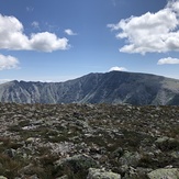
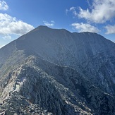
Mount Katahdin Photos
View all
Longfellow Mountains photos (27) |
Appalachians photos (859) |
photos from mountains in United States (2877) |
all photos
 Upload new photo
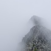
 See 16 more Mount Katahdin photos
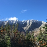
The Knife Edge
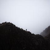
Katahdin
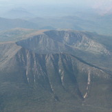
Frosty Tips
Mount Katahdin
Mount Katahdin
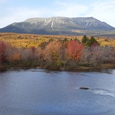
Mt Katahdin 10/11/19

