– Lat/Long: 45.58° S 167.47° E
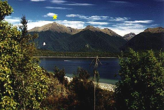
 Mount Moturau
Weather Forecast, New ZealandIssued: 5 pm Thu 17 Apr Local TimeUpdates in: hr min sUpdate imminent
Mount Moturau Weather Forecast, New Zealand
Issued: 5 pm Thu 17 Apr Local Time
Updates in:
Update imminent hr min s

Issued: 5 pm Thu 17 Apr Local Time
Updates in:
Update imminent hr min s
Days 1–4 Weather SummaryModerate rain (total 15mm), heaviest on Sat night. Very mild (max 11°C on Fri morning, min 7°C on Sun morning). Wind will be generally light. | Days 5–7 Weather SummaryMostly dry. Freeze-thaw conditions (max 10°C on Mon night, min -4°C on Tue night). Winds increasing (calm on Sun afternoon, strong winds from the SE by Wed morning). | ||||||||||||||||
Thu 17 | Friday 18 | Saturday 19 | Sunday 20 | Monday 21 | Tuesday 22 | ||||||||||||
PM | night | AM | PM | night | AM | PM | night | AM | PM | night | AM | PM | night | AM | PM | night | |
cloudy | some clouds | some clouds | light rain | light rain | light rain | light rain | heavy rain | rain shwrs | light rain | rain shwrs | clear | cloudy | some clouds | clear | clear | rain shwrs | |
km/h | |||||||||||||||||
 |  |  |  |  |  | ||||||||||||
— | — | — | — | — | — | — | — | — | — | — | — | — | — | — | — | — | |
— | — | — | 0.1 | 1.2 | 1.2 | 1.4 | 10 | 0.6 | 0.2 | 0.1 | — | — | — | — | — | 0.2 | |
max°C | 9 | 9 | 11 | 11 | 11 | 10 | 10 | 10 | 8 | 7 | 5 | 6 | 8 | 10 | 9 | 8 | 6 |
min°C | 9 | 8 | 10 | 10 | 9 | 9 | 10 | 8 | 7 | 6 | 4 | 4 | 8 | 9 | 9 | 8 | -4 |
9 | 6 | 10 | 10 | 7 | 7 | 8 | 8 | 7 | 4 | 0 | 0 | 8 | 9 | 8 | 6 | -12 | |
3350 | 3400 | 3350 | 3450 | 3350 | 3350 | 3400 | 3300 | 3300 | 3200 | 3100 | 3050 | 2900 | 2950 | 3250 | 3100 | 2300 | |
Cloud base (m) | 5250 | 3050 | 2550 | 1700 | 1450 | 450 | 650 | 350 | 350 | 400 | 450 | 650 | 2750 | 750 | |||
— | — | 7:28 | — | — | 7:28 | — | — | 7:30 | — | — | 7:31 | — | — | 7:33 | — | — | |
6:10 | — | — | 6:09 | — | — | 6:07 | — | — | 6:06 | — | — | 6:05 | — | — | 6:02 | — | |
Loading...
Mount Moturau Weather (Days 0-3):
The weather forecast for Mount Moturau is: Moderate rain (total 15mm), heaviest on Sat night. Very mild (max 11°C on Fri morning, min 7°C on Sun morning). Wind will be generally light.
Mount Moturau Weather (Days 3-6):
Mostly dry. Freeze-thaw conditions (max 10°C on Mon night, min -4°C on Tue night). Winds increasing (calm on Sun afternoon, strong winds from the SE by Wed morning).
This table gives the weather forecast for Mount Moturau at the specific elevation of 1497 m. Our advanced weather models allow us to provide distinct weather forecasts for several elevations of Mount Moturau. To see the weather forecasts for the other elevations, use the tab navigation above the table. For a wider overview of the weather, consult the Weather Map of New Zealand.
| Weather Station | Temp. | Weather | Wind | Gusts | Cloud / Visibility |
|---|---|---|---|---|---|
SecretaryIslandAws | |||||
PuysegurPointAws | |||||
Kingston SPHGC | |||||
Glenorchy | |||||
Skyline Gondola |
* NOTE: not all weather observatories update at the same frequency which is the reason why some locations may show data from stations that are further away than known closer ones.
Mount Moturau Photos
View all
Southern Alps photos (34) |
New Zealand photos (120) |
photos from mountains in New Zealand (124) |
all photos
 Upload new photo
Mount Moturau

