
– Lat/Long: 45.74° N 67.33° W
 Mount Pleasant Caldera
Weather Forecast, CanadaIssued: 8 am Sat 19 Apr Local TimeUpdates in: hr min sUpdate imminent
Mount Pleasant Caldera Weather Forecast, Canada
Issued: 8 am Sat 19 Apr Local Time
Updates in:
Update imminent hr min s

Issued: 8 am Sat 19 Apr Local Time
Updates in:
Update imminent hr min s
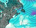
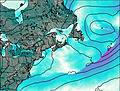
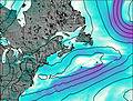
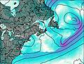
Days 1–3 Weather SummaryLight rain (total 7mm), mostly falling on Sat afternoon. Freeze-thaw conditions (max 14°C on Sat night, min 0°C on Sun night). Winds decreasing (strong winds from the NW on Sun afternoon, calm by Mon night). | Days 4–6 Weather SummaryLight rain (total 6mm), mostly falling on Tue morning. Freeze-thaw conditions (max 12°C on Thu afternoon, min 0°C on Wed night). Wind will be generally light. | |||||||||||||||||
Saturday 19 | Sunday 20 | Monday 21 | Tuesday 22 | Wednesday 23 | Thursday 24 | |||||||||||||
AM | PM | night | AM | PM | night | AM | PM | night | AM | PM | night | AM | PM | night | AM | PM | night | |
light rain | rain shwrs | rain shwrs | rain shwrs | clear | some clouds | clear | some clouds | light rain | light rain | light rain | light rain | light rain | light rain | clear | clear | some clouds | some clouds | |
km/h | ||||||||||||||||||
 |  |  |  |  |  | |||||||||||||
— | — | — | — | — | — | — | — | — | — | — | — | — | — | — | — | — | — | |
2 | 3 | 0.7 | 0.2 | — | — | — | — | 1.0 | 3 | 1.7 | 1.4 | 0.2 | 0.2 | — | — | — | — | |
max°C | 9 | 13 | 14 | 4 | 7 | 4 | 6 | 10 | 7 | 3 | 4 | 4 | 5 | 5 | 4 | 9 | 12 | 8 |
min°C | 6 | 12 | 7 | 3 | 6 | 0 | 1 | 9 | 3 | 3 | 3 | 3 | 5 | 5 | 0 | 4 | 11 | 3 |
4 | 10 | 3 | -3 | 0 | -6 | -5 | 7 | 0 | -1 | -1 | 3 | 2 | 2 | -3 | 0 | 9 | 1 | |
2950 | 3450 | 3150 | 600 | 850 | 550 | 900 | 1200 | 1350 | 1200 | 1950 | 1500 | 1150 | 1100 | 1200 | 1000 | 1400 | 1450 | |
Cloud base (m) | 1500 | 350 | 150 | 400 | 550 | 550 | 250 | 3550 | 350 | 150 | 150 | 150 | 150 | 400 | 6050 | 800 | 1900 | |
6:37 | — | — | 6:35 | — | — | 6:33 | — | — | 6:31 | — | — | 6:30 | — | — | 6:28 | — | — | |
— | 8:20 | — | — | 8:21 | — | — | 8:22 | — | — | 8:23 | — | — | 8:24 | — | — | 8:27 | — | |
Loading...
Mount Pleasant Caldera Weather (Days 0-3):
The weather forecast for Mount Pleasant Caldera is: Light rain (total 7mm), mostly falling on Sat afternoon. Freeze-thaw conditions (max 14°C on Sat night, min 0°C on Sun night). Winds decreasing (strong winds from the NW on Sun afternoon, calm by Mon night).
Mount Pleasant Caldera Weather (Days 3-6):
Light rain (total 6mm), mostly falling on Tue morning. Freeze-thaw conditions (max 12°C on Thu afternoon, min 0°C on Wed night). Wind will be generally light.
This table gives the weather forecast for Mount Pleasant Caldera at the specific elevation of 248 m. Our advanced weather models allow us to provide distinct weather forecasts for several elevations of Mount Pleasant Caldera. To see the weather forecasts for the other elevations, use the tab navigation above the table. For a wider overview of the weather, consult the Weather Map of New-Brunswick.
| Weather Station | Temp. | Weather | Wind | Gusts | Cloud / Visibility |
|---|---|---|---|---|---|
St.Stephen-NB | |||||
St. Stephen Airport | |||||
Fredericton-NB | |||||
Fredericton Airport |
* NOTE: not all weather observatories update at the same frequency which is the reason why some locations may show data from stations that are further away than known closer ones.

