
– Lat/Long: 73.07° S 165.70° E
 Mount Supernal
Weather Forecast, AntarcticaIssued: 6 pm Sun 14 Dec Local TimeUpdates in: hr min sUpdate imminent
Issued: 6 pm Sun 14 Dec Local Time
Updates in:
Update imminent hr min s

Issued: 6 pm Sun 14 Dec Local Time
Updates in:
Update imminent hr min s
Days 1–4 Weather SummaryA light covering of new snow mostly falling on Tue afternoon. Extremely cold (max -17°C on Tue morning, min -24°C on Sun afternoon). Winds decreasing (near gales from the WNW on Mon night, light winds from the NNE by Wed morning). | Days 5–7 Weather SummaryA light covering of new snow mostly falling on Wed afternoon. Extremely cold (max -20°C on Sat morning, min -26°C on Wed afternoon). Wind will be generally light. | ||||||||||||||||
Sun 14 | Monday 15 | Tuesday 16 | Wednesday 17 | Thursday 18 | Friday 19 | ||||||||||||
PM | night | AM | PM | night | AM | PM | night | AM | PM | night | AM | PM | night | AM | PM | night | |
some clouds | clear | clear | clear | clear | some clouds | light snow | snow shwrs | snow shwrs | light snow | snow shwrs | snow shwrs | light snow | light snow | some clouds | some clouds | some clouds | |
km/h | |||||||||||||||||
 |  |  |  |  |  | ||||||||||||
— | — | — | — | — | — | 1 | 3 | 1 | 2 | 3 | 1 | 2 | 1 | — | — | — | |
— | — | — | — | — | — | — | — | — | — | — | — | — | — | — | — | — | |
max°C | -24 | -23 | -23 | -23 | -19 | -17 | -18 | -21 | -23 | -25 | -26 | -26 | -26 | -24 | -23 | -22 | -21 |
min°C | -24 | -24 | -24 | -24 | -23 | -17 | -18 | -23 | -24 | -26 | -26 | -26 | -26 | -26 | -23 | -23 | -23 |
-34 | -34 | -38 | -38 | -38 | -30 | -28 | -36 | -31 | -36 | -37 | -36 | -37 | -36 | -23 | -28 | -28 | |
0 | 0 | 0 | 0 | 0 | 300 | 200 | 0 | 0 | 0 | 0 | 0 | 0 | 0 | 0 | 250 | 0 | |
Cloud base (m) | 4550 | 2050 | 2050 | 2050 | 2050 | 2050 | 2050 | 2050 | 2050 | 2100 | 2100 | ||||||
— | — | 12:00 | — | — | 12:00 | — | — | 12:00 | — | — | 12:00 | — | — | 12:00 | — | — | |
12:00 | — | 12:00 | — | — | 12:00 | — | — | 12:00 | — | — | 12:00 | — | — | 12:00 | — | — | |
Loading...
Mount Supernal Weather (Days 0-3):
The weather forecast for Mount Supernal is: A light covering of new snow mostly falling on Tue afternoon. Extremely cold (max -17°C on Tue morning, min -24°C on Sun afternoon). Winds decreasing (near gales from the WNW on Mon night, light winds from the NNE by Wed morning).
Mount Supernal Weather (Days 3-6):
A light covering of new snow mostly falling on Wed afternoon. Extremely cold (max -20°C on Sat morning, min -26°C on Wed afternoon). Wind will be generally light.
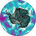
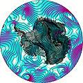
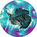
This table gives the weather forecast for Mount Supernal at the specific elevation of 3655 m. Our advanced weather models allow us to provide distinct weather forecasts for several elevations of Mount Supernal. To see the weather forecasts for the other elevations, use the tab navigation above the table. For a wider overview of the weather, consult the Weather Map of Antarctica.
| Weather Station | Temp. | Weather | Wind | Gusts | Cloud / Visibility |
|---|---|---|---|---|---|
SHIP7145 | |||||
Williams Field | |||||
Phoenix Field- McMurdo Station | |||||
SHIP8906 | |||||
ASCATC246E74S | |||||
ASCATC247E74S |
* NOTE: not all weather observatories update at the same frequency which is the reason why some locations may show data from stations that are further away than known closer ones.