
– Lat/Long: 47.87° N 123.06° W
 Mount Townsend
Weather Forecast, United StatesIssued: 4 am Sun 11 May Local TimeUpdates in: hr min sUpdate imminent
Issued: 4 am Sun 11 May Local Time
Updates in:
Update imminent hr min s

Issued: 4 am Sun 11 May Local Time
Updates in:
Update imminent hr min s
Days 1–3 Weather SummaryA light covering of new snow mostly falling on Sun afternoon. Freeze-thaw conditions (max 2°C on Tue morning, min -2°C on Sun afternoon). Wind will be generally light. | Days 4–6 Weather SummaryA dusting of new snow. Freeze-thaw conditions (max 2°C on Wed afternoon, min 0°C on Wed night). Wind will be generally light. | |||||||||||||||||
Sunday 11 | Monday 12 | Tuesday 13 | Wednesday 14 | Thursday 15 | Friday 16 | |||||||||||||
AM | PM | night | AM | PM | night | AM | PM | night | AM | PM | night | AM | PM | night | AM | PM | night | |
cloudy | light snow | light snow | cloudy | light snow | some clouds | some clouds | cloudy | cloudy | some clouds | cloudy | some clouds | cloudy | light snow | light snow | some clouds | some clouds | cloudy | |
km/h | ||||||||||||||||||
 |  |  |  |  |  | |||||||||||||
— | 2.0 | 1.0 | — | 2.0 | — | — | — | — | — | — | — | — | 1.0 | 1.0 | — | — | — | |
— | — | — | — | — | — | — | — | — | — | — | — | — | — | — | — | — | — | |
max°C | -1 | -1 | -2 | -2 | -1 | 1 | 2 | 2 | 2 | 1 | 2 | 1 | 0 | 0 | 0 | 0 | 1 | 1 |
min°C | -1 | -2 | -2 | -2 | -1 | 1 | 2 | 2 | 1 | 1 | 1 | 0 | 0 | 0 | 0 | 0 | 1 | 0 |
-5 | -2 | -2 | -5 | -3 | -3 | -1 | 0 | -2 | -1 | -1 | -4 | -4 | -4 | -2 | -4 | -2 | -2 | |
1800 | 1650 | 1500 | 1650 | 1800 | 2100 | 2300 | 2300 | 2100 | 2250 | 2350 | 2150 | 2050 | 1900 | 1900 | 1950 | 2150 | 2050 | |
Cloud base (m) | 1550 | 1400 | 400 | 450 | 500 | 1700 | 850 | 700 | 450 | 450 | 550 | 550 | 500 | 450 | 450 | 450 | 450 | 1850 |
5:39 | — | — | 5:37 | — | — | 5:37 | — | — | 5:35 | — | — | 5:33 | — | — | 5:33 | — | — | |
— | — | 8:37 | — | — | 8:38 | — | — | 8:40 | — | — | 8:42 | — | — | 8:43 | — | — | 8:44 | |
Loading...
Mount Townsend Weather (Days 0-3):
The weather forecast for Mount Townsend is: A light covering of new snow mostly falling on Sun afternoon. Freeze-thaw conditions (max 2°C on Tue morning, min -2°C on Sun afternoon). Wind will be generally light.
Mount Townsend Weather (Days 3-6):
A dusting of new snow. Freeze-thaw conditions (max 2°C on Wed afternoon, min 0°C on Wed night). Wind will be generally light.
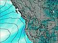
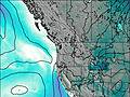
This table gives the weather forecast for Mount Townsend at the specific elevation of 1914 m. Our advanced weather models allow us to provide distinct weather forecasts for several elevations of Mount Townsend. To see the weather forecasts for the other elevations, use the tab navigation above the table. For a wider overview of the weather, consult the Weather Map of Washington.