
– Lat/Long: 37.45° N 79.58° W
 Peaks of Otter
Weather Forecast, United StatesIssued: 7 pm Fri 25 Apr Local TimeUpdates in: hr min sUpdate imminent
Peaks of Otter Weather Forecast, United States
Issued: 7 pm Fri 25 Apr Local Time
Updates in:
Update imminent hr min s

Issued: 7 pm Fri 25 Apr Local Time
Updates in:
Update imminent hr min s
Days 1–4 Weather SummaryLight rain (total 8mm), mostly falling on Fri night. Very mild (max 14°C on Fri night, min 7°C on Sun night). Winds decreasing (strong winds from the NW on Sat night, calm by Sun night). | Days 5–7 Weather SummaryLight rain (total 2mm), mostly falling on Tue night. Very mild (max 18°C on Tue afternoon, min 11°C on Mon night). Winds decreasing (near gales from the WNW on Tue night, light winds from the W by Wed night). | ||||||||||||||||||
Saturday 26 | Sunday 27 | Monday 28 | Tuesday 29 | Wednesday 30 | Thursday 1 | ||||||||||||||
night | AM | PM | night | AM | PM | night | AM | PM | night | AM | PM | night | AM | PM | night | AM | PM | night | |
mod. rain | rain shwrs | rain shwrs | clear | clear | clear | clear | clear | clear | clear | clear | some clouds | risk tstorm | clear | some clouds | light rain | some clouds | rain shwrs | rain shwrs | |
km/h | |||||||||||||||||||
 |  |  |  |  |  |  | |||||||||||||
— | — | — | — | — | — | — | — | — | — | — | — | — | — | — | — | — | — | — | |
6 | 2.0 | 0.2 | — | — | — | — | — | — | — | — | — | 1.2 | — | — | 1.1 | — | 0.1 | 4 | |
max°C | 14 | 12 | 14 | 9 | 9 | 12 | 11 | 10 | 13 | 13 | 16 | 18 | 17 | 15 | 18 | 16 | 14 | 16 | 16 |
min°C | 13 | 12 | 13 | 8 | 9 | 10 | 7 | 8 | 11 | 11 | 13 | 17 | 15 | 15 | 17 | 12 | 13 | 14 | 15 |
10 | 9 | 10 | 3 | 4 | 8 | 5 | 6 | 9 | 8 | 11 | 16 | 12 | 12 | 16 | 11 | 12 | 13 | 13 | |
3450 | 3450 | 3650 | 3450 | 3400 | 3450 | 3350 | 3450 | 3650 | 3900 | 3750 | 3700 | 3900 | 3800 | 3550 | 3550 | 3650 | 3550 | 3650 | |
Cloud base (m) | 850 | 400 | 1700 | 8750 | 9350 | 2350 | 4750 | 750 | 2300 | 1900 | 1900 | 1600 | 300 | ||||||
— | 6:28 | — | — | 6:28 | — | — | 6:26 | — | — | 6:26 | — | — | 6:24 | — | — | 6:22 | — | — | |
— | — | — | 8:02 | — | — | 8:04 | — | — | 8:05 | — | — | 8:05 | — | — | 8:06 | — | — | 8:07 | |
Loading...
Peaks of Otter Weather (Days 0-3):
The weather forecast for Peaks of Otter is: Light rain (total 8mm), mostly falling on Fri night. Very mild (max 14°C on Fri night, min 7°C on Sun night). Winds decreasing (strong winds from the NW on Sat night, calm by Sun night).
Peaks of Otter Weather (Days 3-6):
Light rain (total 2mm), mostly falling on Tue night. Very mild (max 18°C on Tue afternoon, min 11°C on Mon night). Winds decreasing (near gales from the WNW on Tue night, light winds from the W by Wed night).
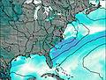
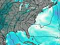
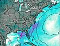
This table gives the weather forecast for Peaks of Otter at the specific elevation of 1217 m. Our advanced weather models allow us to provide distinct weather forecasts for several elevations of Peaks of Otter. To see the weather forecasts for the other elevations, use the tab navigation above the table. For a wider overview of the weather, consult the Weather Map of Virginia.
| Weather Station | Temp. | Weather | Wind | Gusts | Cloud / Visibility |
|---|---|---|---|---|---|
Roanoke Airport | |||||
Lynchburg Airport | |||||
Hot Spring / ngalls Field Airport | |||||
lightning 33km NNW of Lexington | |||||
lightning 34km N of Clifton Forge | |||||
Blacksbur / irginia Tech Montgomery Executive Airport | |||||
* NOTE: not all weather observatories update at the same frequency which is the reason why some locations may show data from stations that are further away than known closer ones.
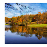
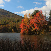
Peaks of Otter Photos
View all
Blue Ridge Mountains photos (161) |
Appalachians photos (861) |
photos from mountains in United States (2891) |
all photos
 Upload new photo


 See 9 more Peaks of Otter photos
Peaks of Otter Panorama
Peaks of Otter sunset
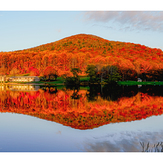
Peaks of Otter Autumn Afternoon
Reflections
Peak reflection
Peaks of Otter Autumn
Fall of 2024

