– Lat/Long: 42.42° N 2.16° E
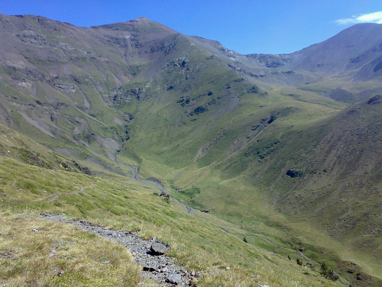
 Pic d'Eina
Weather Forecast, SpainIssued: 7 pm Thu 24 Apr Local TimeUpdates in: hr min sUpdate imminent
Pic d'Eina Weather Forecast, Spain
Issued: 7 pm Thu 24 Apr Local Time
Updates in:
Update imminent hr min s

Issued: 7 pm Thu 24 Apr Local Time
Updates in:
Update imminent hr min s
Days 1–4 Weather SummaryDrizzle on Fri night followed by colder weather and a heavy fall of snow, heaviest during Sat night. Freeze-thaw conditions (max 4°C on Thu night, min -4°C on Sat night). Winds increasing (light winds from the WNW on Fri night, fresh winds from the NNW by Sat night). | Days 5–7 Weather SummaryMostly dry. Freeze-thaw conditions (max 5°C on Wed afternoon, min -2°C on Sun night). Wind will be generally light. | ||||||||||||||||||
Friday 25 | Saturday 26 | Sunday 27 | Monday 28 | Tuesday 29 | Wednesday 30 | ||||||||||||||
night | AM | PM | night | AM | PM | night | AM | PM | night | AM | PM | night | AM | PM | night | AM | PM | night | |
clear | clear | clear | rain shwrs | some clouds | mod. snow | snow shwrs | light snow | cloudy | clear | some clouds | some clouds | clear | clear | some clouds | some clouds | some clouds | some clouds | some clouds | |
km/h | |||||||||||||||||||
 |  |  |  |  |  |  | |||||||||||||
— | — | — | — | — | 9 | 10 | 1.0 | — | — | — | — | — | — | — | — | — | — | — | |
— | — | — | 1.7 | — | — | — | — | — | — | — | — | — | — | — | — | — | — | — | |
max°C | 4 | 4 | 4 | 4 | 1 | -1 | -3 | -4 | -3 | -2 | 0 | 0 | 1 | 2 | 2 | 4 | 4 | 5 | 6 |
min°C | 3 | 4 | 4 | 2 | 0 | -2 | -4 | -4 | -3 | -2 | -1 | -1 | 0 | 1 | 2 | 3 | 3 | 4 | 5 |
-2 | 0 | 1 | -1 | -4 | -5 | -11 | -12 | -10 | -8 | -4 | -1 | -4 | -3 | -2 | 0 | -1 | 0 | 0 | |
3500 | 3400 | 3350 | 3300 | 2850 | 2300 | 2100 | 2150 | 2350 | 2300 | 2750 | 2750 | 2900 | 3100 | 3050 | 3350 | 3450 | 3450 | 3750 | |
Cloud base (m) | 5950 | 1950 | 1850 | 1850 | 1850 | 1850 | 2050 | 2350 | 2100 | 2400 | 2850 | 7150 | 7100 | 6900 | |||||
— | 6:54 | — | — | 6:54 | — | — | 6:52 | — | — | 6:50 | — | — | 6:50 | — | — | 6:48 | — | — | |
— | — | — | 8:43 | — | — | 8:44 | — | — | 8:45 | — | — | 8:46 | — | — | 8:47 | — | — | 8:49 | |
Loading...
Pic d'Eina Weather (Days 0-3):
The weather forecast for Pic d'Eina is: Drizzle on Fri night followed by colder weather and a heavy fall of snow, heaviest during Sat night. Freeze-thaw conditions (max 4°C on Thu night, min -4°C on Sat night). Winds increasing (light winds from the WNW on Fri night, fresh winds from the NNW by Sat night).
Pic d'Eina Weather (Days 3-6):
Mostly dry. Freeze-thaw conditions (max 5°C on Wed afternoon, min -2°C on Sun night). Wind will be generally light.
This table gives the weather forecast for Pic d'Eina at the specific elevation of 2789 m. Our advanced weather models allow us to provide distinct weather forecasts for several elevations of Pic d'Eina. To see the weather forecasts for the other elevations, use the tab navigation above the table. For a wider overview of the weather, consult the Weather Map of Spain.
| Weather Station | Temp. | Weather | Wind | Gusts | Cloud / Visibility |
|---|---|---|---|---|---|
La Molina | |||||
Cap del Rec | |||||
VIGNE DEL REY | |||||
Perpignan | |||||
1336 | |||||
Giron / osta Brava | |||||
Port Ainé Massís de l'Orri | |||||
môle Port-Vendres |
* NOTE: not all weather observatories update at the same frequency which is the reason why some locations may show data from stations that are further away than known closer ones.
Pic d'Eina Photos
View all
photos (95) |
Pyrenees photos (134) |
photos from mountains in Spain (434) |
all photos
 Upload new photo
Pic d'Eina

