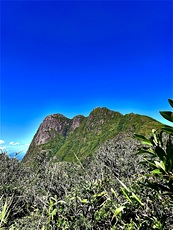
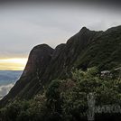
Pico Paraná cannot be considered an easy trail: it is long and requires prior preparation. It is not recommended for beginners. For all intents and purposes, it is considered a "moderate" level trail, with segments that demand a lot of attention. Plan for at least 6 hours of hiking to reach the summit. Those with good experience and preparation may do it in 4 to 5 hours.
The best months to hike, without a doubt, are the winter months in the southern hemisphere, especially June, July, and August, because this is when the average precipitation is lower, the trails are drier, and insects are much less prevalent. However, the cold can be an issue for some: it is not uncommon to encounter freezing rain or snow at the summit, and the wind chill can drop to -10 degrees Celsius on the coldest mornings, so it is advisable to be prepared. Aside from the temperature spikes caused by seasonal polar air masses, the typical minimum temperatures recorded during this period range between +2 and +5 degrees Celsius.
Despite being the highest peak in the range, Pico Paraná is not considered the most difficult climb in the area. This is a subject of controversy among local mountaineers, who cannot decide whether the title belongs to Ferraria, Taipabuçu, Ciririca, or Agudo da Cotia peaks.
For less experienced hikers, it is highly suggested to climb some other peaks considered less demanding before heading to Pico Paraná. In the same section of it, there are Itapiroca and Caratuva peaks, the latter being a bit more difficult than the former but still at a friendly level for beginners. A few kilometers to the south, but still in the same mountain range, are Camapuã and Tucum, excellent mountains for beginners, which can be conquered in around a 3-hour hike.
It is highly recommended to use GPS and pre-recorded tracks in applications like Wikiloc on the mountain. The region is vast, and it is not uncommon for mountaineers to lose their way. A miscalculation in the route can take many hours or even days to correct. Depending on the weather, rainfall, and the movement of hikers, the trails can vary greatly within a few days. Paths in dense forest can quickly become overgrown after consecutive rainy days and/or little hiking activity. Even without rain, the humidity levels are always high, and it is possible that some sections of the trails (or even the terrain at the summits) to be in very difficult conditions due to mud accumulation, which dries in a slower pace during the winter.
Additional care is also needed with rocks, roots, and gullies that suddenly appear along the trails. The risk of ankle sprain should not be underestimated, and rescue options are very limited in these mountains as they are quite remote. It is recommended to be very careful with each step and to complete the routes calmly, without rushing, to minimize the possibility of injuries.
Access is through farms located in private areas, with free passage, but a small fee (around 3-5 USD) is charged per person for conservation purposes. Parking is available for an extra fee. One of the farms (Sítio Pico Paraná) gives access to trails that lead directly to the Pico Paraná-Caratuva-Itapiroca-Ferraria complex, and the other (Sítio do Bolinha) leads to the Camapuã-Tucum-Ciririca set. Both trails are connected at some points and it's virtually possible to hike from one farm to another, although after an endeavor of many hours. Both farms are located at the end of dirt roads, approximately 6 km from the Curitiba-São Paulo highway.
There is no public transportation to the area. The mountains and the farms that provide access to them are about 40 km from downtown Curitiba. Basically, transportation is only possible by private car, but it's possible, although challenging, to negotiate with a taxi/uber to reach the farms. To return, these options are not available, since there are no taxi/uber coverage on the area. If you aren't in a group with local people, the only comprehensive ways to secure your way back are to pre-schedule your driver, or to rent a car and drive yourself to the farms, by far the most convenient option and cost-effective if you're in a group of at least 3 people.
Generally, adventurers schedule accommodation in Curitiba, a large city with a lot of options and amenities. While in Curitiba, exercise common sense when walking in public areas and take precautions you commonly need in large metropolitan areas. For overnight stays, less distant options are limited, but it is possible to find simple hotels in the municipality of Quatro Barras, 20 km from the farms, or in small establishments along the highway, still at least 10 km from the access to the mountains.


 Like us
 Follow us
 Follow us