– Lat/Long: 45.11° N 2.68° E
 Puy Mary
Weather Forecast, FranceIssued: 1 pm Sat 19 Apr Local TimeUpdates in: hr min sUpdate imminent
Puy Mary Weather Forecast, France
Issued: 1 pm Sat 19 Apr Local Time
Updates in:
Update imminent hr min s

Issued: 1 pm Sat 19 Apr Local Time
Updates in:
Update imminent hr min s
Days 1–4 Weather SummaryModerate rain (total 13mm), heaviest on Sat night giving way to a moderate fall of snow, heaviest on Sat night. Freeze-thaw conditions (max 6°C on Sat afternoon, min -1°C on Sat night). Winds decreasing (severe gales from the SSE on Sat afternoon, light winds from the NW by Tue morning). | Days 5–7 Weather SummaryLight rain (total 6mm), mostly falling on Wed night. Mild temperatures (max 5°C on Tue afternoon, min 2°C on Tue night). Winds increasing (light winds from the NW on Tue afternoon, strong winds from the W by Wed night). | ||||||||||||||||
Sat 19 | Sunday 20 | Monday 21 | Tuesday 22 | Wednesday 23 | Thursday 24 | ||||||||||||
PM | night | AM | PM | night | AM | PM | night | AM | PM | night | AM | PM | night | AM | PM | night | |
rain shwrs | mod. snow | some clouds | rain shwrs | light snow | light rain | light rain | rain shwrs | some clouds | rain shwrs | rain shwrs | cloudy | light rain | light rain | light rain | light rain | rain shwrs | |
km/h | |||||||||||||||||
 |  |  |  |  |  | ||||||||||||
— | 9 | — | — | 4 | — | — | — | — | — | — | — | — | — | — | — | — | |
0.3 | 8 | — | 0.8 | 1.0 | 1.9 | 1.1 | 0.3 | — | 0.2 | 0.1 | — | 0.3 | 3 | 0.9 | 0.7 | 0.4 | |
max°C | 6 | 2 | 2 | 4 | 3 | 2 | 3 | 3 | 2 | 5 | 5 | 2 | 2 | 4 | 3 | 4 | 5 |
min°C | 5 | -1 | 1 | 4 | 1 | 2 | 2 | 1 | 1 | 4 | 2 | 2 | 2 | 3 | 3 | 3 | 4 |
-3 | -7 | -5 | -2 | -6 | -4 | -3 | -2 | -2 | 2 | -1 | -1 | -2 | -3 | -3 | -3 | 0 | |
2500 | 1450 | 1850 | 2100 | 1750 | 1900 | 2050 | 2050 | 2000 | 2300 | 2000 | 1900 | 1950 | 2300 | 2550 | 2600 | 2700 | |
Cloud base (m) | 1550 | 700 | 700 | 1950 | 750 | 700 | 850 | 850 | 1550 | 1950 | 2050 | 950 | 1700 | 750 | 750 | 850 | 950 |
— | — | 6:56 | — | — | 6:54 | — | — | 6:52 | — | — | 6:52 | — | — | 6:50 | — | — | |
— | 8:38 | — | — | 8:39 | — | — | 8:40 | — | — | 8:43 | — | — | 8:44 | — | — | 8:45 | |
Loading...
Puy Mary Weather (Days 0-3):
The weather forecast for Puy Mary is: Moderate rain (total 13mm), heaviest on Sat night giving way to a moderate fall of snow, heaviest on Sat night. Freeze-thaw conditions (max 6°C on Sat afternoon, min -1°C on Sat night). Winds decreasing (severe gales from the SSE on Sat afternoon, light winds from the NW by Tue morning).
Puy Mary Weather (Days 3-6):
Light rain (total 6mm), mostly falling on Wed night. Mild temperatures (max 5°C on Tue afternoon, min 2°C on Tue night). Winds increasing (light winds from the NW on Tue afternoon, strong winds from the W by Wed night).
This table gives the weather forecast for Puy Mary at the specific elevation of 1500 m. Our advanced weather models allow us to provide distinct weather forecasts for several elevations of Puy Mary. To see the weather forecasts for the other elevations, use the tab navigation above the table. For a wider overview of the weather, consult the Weather Map of France.
| Weather Station | Temp. | Weather | Wind | Gusts | Cloud / Visibility |
|---|---|---|---|---|---|
lightning 7km N of Sainte-Genevieve-sur-Argence | |||||
Aurillac (automatic) | |||||
Valbeleix | |||||
lightning 7km W of Saint-Mamet-la-Salvetat | |||||
Puy de la Tâche (63) | |||||
* NOTE: not all weather observatories update at the same frequency which is the reason why some locations may show data from stations that are further away than known closer ones.
Puy Mary Photos
View all
Chaîne des Puys photos (5) |
Massif Central photos (9) |
photos from mountains in France (280) |
all photos
 Upload new photo
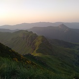
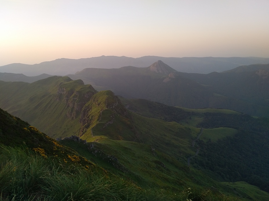
Puy Mary, Cantal, FR
Puy Mary, Cantal, FR
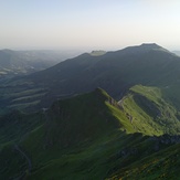
Puy Mary, Cantal, FR

