– Lat/Long: 57.37° N 5.06° W
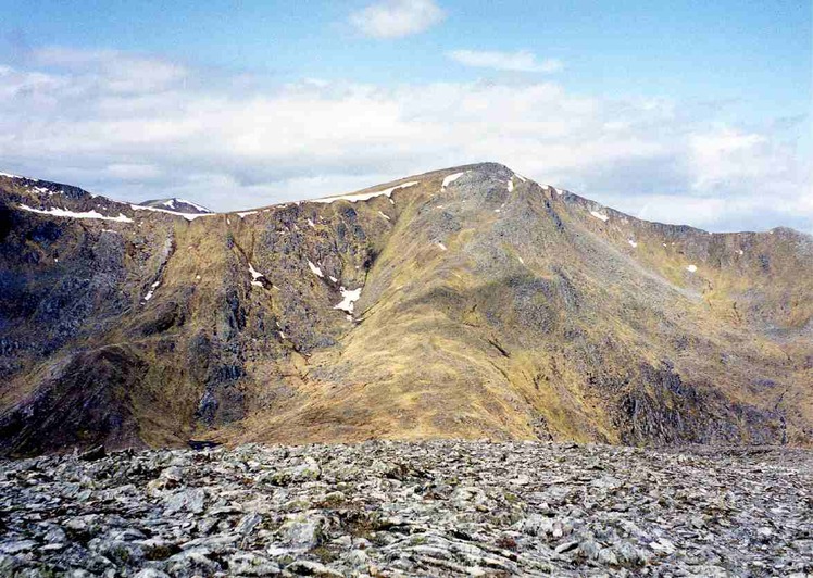
 Sgùrr na Lapaich
Weather Forecast, United KingdomIssued: 12 pm Sat 19 Apr Local TimeUpdates in: hr min sUpdate imminent
Sgùrr na Lapaich Weather Forecast, United Kingdom
Issued: 12 pm Sat 19 Apr Local Time
Updates in:
Update imminent hr min s

Issued: 12 pm Sat 19 Apr Local Time
Updates in:
Update imminent hr min s
Days 1–3 Weather SummaryA light covering of new snow mostly falling on Sat morning. Freeze-thaw conditions (max 4°C on Sun afternoon, min -1°C on Sat morning). Winds decreasing (fresh winds from the ESE on Sat morning, calm by Mon afternoon). | Days 4–6 Weather SummaryA dusting of new snow. Freeze-thaw conditions (max 5°C on Thu afternoon, min 0°C on Tue morning). Winds decreasing (fresh winds from the ESE on Wed afternoon, light winds from the SSW by Thu night). | |||||||||||||||||
Saturday 19 | Sunday 20 | Monday 21 | Tuesday 22 | Wednesday 23 | Thursday 24 | |||||||||||||
AM | PM | night | AM | PM | night | AM | PM | night | AM | PM | night | AM | PM | night | AM | PM | night | |
light snow | cloudy | cloudy | some clouds | some clouds | some clouds | cloudy | light snow | snow shwrs | cloudy | light snow | cloudy | cloudy | rain shwrs | rain shwrs | clear | some clouds | clear | |
km/h | ||||||||||||||||||
 |  |  |  |  |  | |||||||||||||
3 | — | — | — | — | — | — | 2.0 | 2.0 | — | 2.0 | — | — | — | — | — | — | — | |
— | — | — | — | — | — | — | 0.3 | — | — | — | — | — | 0.1 | 0.1 | — | — | — | |
max°C | 0 | 1 | 1 | 2 | 4 | 3 | 4 | 3 | 1 | 1 | 1 | 1 | 1 | 2 | 3 | 3 | 5 | 2 |
min°C | -1 | 1 | 0 | 2 | 4 | 3 | 3 | 1 | -1 | 0 | 1 | 0 | 0 | 2 | 2 | 3 | 4 | 2 |
-9 | -5 | -6 | -2 | 0 | -1 | 0 | -2 | -7 | -5 | -3 | -5 | -5 | -5 | -4 | -2 | 0 | -2 | |
1000 | 1250 | 1200 | 1550 | 1750 | 1700 | 1650 | 1550 | 1150 | 1100 | 1250 | 1250 | 1200 | 1400 | 1500 | 1750 | 1800 | 1700 | |
Cloud base (m) | 350 | 400 | 650 | 550 | 2150 | 1550 | 1650 | 700 | 350 | 650 | 500 | 350 | 400 | 400 | 650 | 400 | 850 | 450 |
6:01 | — | — | 5:58 | — | — | 5:56 | — | — | 5:54 | — | — | 5:50 | — | — | 5:48 | — | — | |
— | 8:37 | — | — | 8:39 | — | — | 8:42 | — | — | 8:44 | — | — | 8:45 | — | — | 8:49 | — | |
Loading...
Sgùrr na Lapaich Weather (Days 0-3):
The weather forecast for Sgùrr na Lapaich is: A light covering of new snow mostly falling on Sat morning. Freeze-thaw conditions (max 4°C on Sun afternoon, min -1°C on Sat morning). Winds decreasing (fresh winds from the ESE on Sat morning, calm by Mon afternoon).
Sgùrr na Lapaich Weather (Days 3-6):
A dusting of new snow. Freeze-thaw conditions (max 5°C on Thu afternoon, min 0°C on Tue morning). Winds decreasing (fresh winds from the ESE on Wed afternoon, light winds from the SSW by Thu night).
This table gives the weather forecast for Sgùrr na Lapaich at the specific elevation of 1150 m. Our advanced weather models allow us to provide distinct weather forecasts for several elevations of Sgùrr na Lapaich. To see the weather forecasts for the other elevations, use the tab navigation above the table. For a wider overview of the weather, consult the Weather Map of United Kingdom.
| Weather Station | Temp. | Weather | Wind | Gusts | Cloud / Visibility |
|---|---|---|---|---|---|
BealachNABA NO 2 | |||||
SAIS C Meagaidh area | |||||
657 | |||||
T17- Nevis Range | |||||
TullochBridge | |||||
SAIS Aonach Mor | |||||
CIC Hut Ben Nevis | |||||
AultbeaNO2 |
* NOTE: not all weather observatories update at the same frequency which is the reason why some locations may show data from stations that are further away than known closer ones.
Sgùrr na Lapaich Photos
View all
Northwest Highlands photos (38) |
Scottish Highlands photos (288) |
photos from mountains in United Kingdom (1953) |
all photos
 Upload new photo
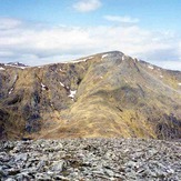
Sgùrr na Lapaich

