
– Lat/Long: 44.13° N 145.17° E
 Shiretoko-iwo-zan
Weather Forecast, JapanIssued: 2 pm Tue 01 Apr Local TimeUpdates in: hr min sUpdate imminent
Shiretoko-iwo-zan Weather Forecast, Japan
Issued: 2 pm Tue 01 Apr Local Time
Updates in:
Update imminent hr min s

Issued: 2 pm Tue 01 Apr Local Time
Updates in:
Update imminent hr min s
Days 1–4 Weather SummaryA moderate fall of snow, heaviest on Thu night. Temperatures will be below freezing (max -2°C on Wed morning, min -6°C on Thu night). Mainly fresh winds. | Days 5–7 Weather SummaryA light covering of new snow mostly falling on Fri afternoon. Freeze-thaw conditions (max 1°C on Sun afternoon, min -6°C on Fri afternoon). Winds decreasing (strong winds from the N on Fri afternoon, light winds from the SW by Sun night). | ||||||||||||||||
Tue 1 | Wednesday 2 | Thursday 3 | Friday 4 | Saturday 5 | Sunday 6 | ||||||||||||
PM | night | AM | PM | night | AM | PM | night | AM | PM | night | AM | PM | night | AM | PM | night | |
clear | clear | some clouds | cloudy | cloudy | some clouds | light snow | light snow | light snow | light snow | snow shwrs | clear | clear | some clouds | cloudy | light snow | light snow | |
km/h | |||||||||||||||||
 |  |  |  |  |  | ||||||||||||
— | — | — | — | — | — | 2.0 | 5 | 4 | 2.0 | 1.0 | — | — | — | — | 1.0 | 1.0 | |
— | — | — | — | — | — | — | — | — | — | — | — | — | — | — | — | — | |
max°C | -3 | -3 | -2 | -2 | -3 | -3 | -4 | -4 | -6 | -6 | -5 | -3 | -2 | -1 | 0 | 1 | 1 |
min°C | -4 | -3 | -2 | -3 | -3 | -3 | -4 | -6 | -6 | -6 | -6 | -4 | -2 | -2 | 0 | 0 | 1 |
-10 | -9 | -8 | -10 | -10 | -10 | -12 | -13 | -14 | -16 | -16 | -12 | -9 | -8 | -5 | -6 | -3 | |
500 | 300 | 350 | 400 | 0 | 0 | 0 | 0 | 0 | 0 | 0 | 300 | 550 | 750 | 950 | 1100 | 1550 | |
Cloud base (m) | 2750 | 350 | 250 | 800 | 150 | 250 | 150 | 150 | 650 | 300 | 200 | 2850 | 200 | ||||
— | — | 4:58 | — | — | 4:58 | — | — | 4:56 | — | — | 4:54 | — | — | 4:52 | — | — | |
5:45 | — | — | 5:45 | — | — | 5:47 | — | — | 5:49 | — | — | 5:50 | — | — | 5:51 | — | |
Shiretoko-iwo-zan Weather (Days 0-3):
The weather forecast for Shiretoko-iwo-zan is: A moderate fall of snow, heaviest on Thu night. Temperatures will be below freezing (max -2°C on Wed morning, min -6°C on Thu night). Mainly fresh winds.
Shiretoko-iwo-zan Weather (Days 3-6):
A light covering of new snow mostly falling on Fri afternoon. Freeze-thaw conditions (max 1°C on Sun afternoon, min -6°C on Fri afternoon). Winds decreasing (strong winds from the N on Fri afternoon, light winds from the SW by Sun night).
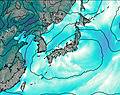
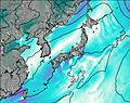
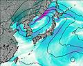
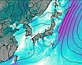
This table gives the weather forecast for Shiretoko-iwo-zan at the specific elevation of 1000 m. Our advanced weather models allow us to provide distinct weather forecasts for several elevations of Shiretoko-iwo-zan. To see the weather forecasts for the other elevations, use the tab navigation above the table. For a wider overview of the weather, consult the Weather Map of Japan.
| Weather Station | Temp. | Weather | Wind | Gusts | Cloud / Visibility |
|---|---|---|---|---|---|
Juzhno -Kuril sk | |||||
Nakashibetsu Airport | |||||
Monbetsu Airport | |||||
Kushiro(47418-1) | |||||
Kushiro Airport | |||||
Mombetsu(South) | |||||
* NOTE: not all weather observatories update at the same frequency which is the reason why some locations may show data from stations that are further away than known closer ones.

