– Lat/Long: 36.06° N 74.96° E
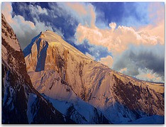
 Spantik Peak
Weather Forecast, PakistanIssued: 4 am Sat 19 Apr Local TimeUpdates in: hr min sUpdate imminent
Spantik Peak Weather Forecast, Pakistan
Issued: 4 am Sat 19 Apr Local Time
Updates in:
Update imminent hr min s

Issued: 4 am Sat 19 Apr Local Time
Updates in:
Update imminent hr min s
Days 1–3 Weather SummaryHeavy rain (total 34mm), heaviest during Sat morning. Mild temperatures (max 9°C on Sat morning, min 1°C on Mon night). Wind will be generally light. | Days 4–6 Weather SummaryLight rain (total 9mm), mostly falling on Thu night. Mild temperatures (max 9°C on Tue morning, min 1°C on Tue night). Wind will be generally light. | |||||||||||||||||
Saturday 19 | Sunday 20 | Monday 21 | Tuesday 22 | Wednesday 23 | Thursday 24 | |||||||||||||
AM | PM | night | AM | PM | night | AM | PM | night | AM | PM | night | AM | PM | night | AM | PM | night | |
mod. rain | mod. rain | heavy rain | rain shwrs | rain shwrs | light rain | rain shwrs | rain shwrs | rain shwrs | rain shwrs | rain shwrs | some clouds | rain shwrs | rain shwrs | light rain | rain shwrs | light rain | light rain | |
km/h | ||||||||||||||||||
 |  |  |  |  |  | |||||||||||||
— | — | — | — | — | — | — | — | — | — | — | — | — | — | — | — | — | — | |
6 | 5 | 14 | 0.4 | 0.4 | 4 | 1.6 | 1.3 | 1.2 | 0.2 | 0.3 | — | 0.2 | 0.5 | 0.3 | 1.0 | 2.0 | 4 | |
max°C | 9 | 9 | 7 | 9 | 9 | 5 | 8 | 9 | 5 | 9 | 9 | 4 | 8 | 9 | 5 | 8 | 8 | 6 |
min°C | 7 | 8 | 5 | 7 | 7 | 2 | 7 | 8 | 1 | 6 | 8 | 1 | 6 | 8 | 3 | 6 | 8 | 6 |
5 | 6 | 2 | 4 | 5 | -1 | 5 | 6 | -2 | 4 | 7 | -2 | 5 | 8 | 1 | 5 | 7 | 5 | |
3800 | 3750 | 3450 | 3700 | 3500 | 2850 | 3650 | 3700 | 2800 | 3700 | 3700 | 2950 | 3650 | 3700 | 3200 | 3600 | 3650 | 3400 | |
Cloud base (m) | 5100 | 5050 | 5100 | 5150 | 5550 | 5700 | 5100 | 5550 | 5350 | 5100 | 6100 | 6250 | 6700 | 6000 | 5500 | 5100 | 5200 | 5050 |
5:22 | — | — | 5:20 | — | — | 5:18 | — | — | 5:18 | — | — | 5:16 | — | — | 5:16 | — | — | |
— | 6:36 | — | — | 6:37 | — | — | 6:37 | — | — | 6:38 | — | — | 6:39 | — | — | 6:40 | — | |
Loading...
Spantik Peak Weather (Days 0-3):
The weather forecast for Spantik Peak is: Heavy rain (total 34mm), heaviest during Sat morning. Mild temperatures (max 9°C on Sat morning, min 1°C on Mon night). Wind will be generally light.
Spantik Peak Weather (Days 3-6):
Light rain (total 9mm), mostly falling on Thu night. Mild temperatures (max 9°C on Tue morning, min 1°C on Tue night). Wind will be generally light.
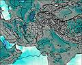
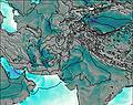
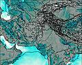
This table gives the weather forecast for Spantik Peak at the specific elevation of 2500 m. Our advanced weather models allow us to provide distinct weather forecasts for several elevations of Spantik Peak. To see the weather forecasts for the other elevations, use the tab navigation above the table. For a wider overview of the weather, consult the Weather Map of Pakistan.
* NOTE: not all weather observatories update at the same frequency which is the reason why some locations may show data from stations that are further away than known closer ones.
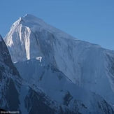
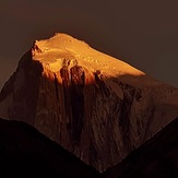
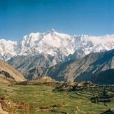
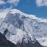
Spantik Peak Photos
View all
Karakoram photos (41) |
Greater Himalaya photos (216) |
photos from mountains in Pakistan (86) |
all photos
 Upload new photo
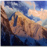

 See 9 more Spantik Peak photos
Golden Peak 7027 Saleh
Golden peak Nagar Hoper
Karakorum
Golden peak
Hoper valley Golden peak starting point
Golden Oeak from Rush lake
Golden peak rent car

