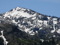
Tells Peak guide
- Elevation: 2704 m
- Difficulty:
- Best months to climb:
- Convenient center:
Tells Peak Climbing Notes
Crystal from UNITED STATES writes:
Its beautiful. You can see five lakes from 360 degrees around you. There used to be a jar in a cairn at the top of the peak where you can write a note and leave it for other hikers. I was there years ago, wish I could do it again. You can camp at the base by Lake number 5 (I think). There is a small high country fresh water lake, and a small flat meadow.
2018-08-20 |
Click here to submit your own climbing note for Tells Peak
|

Select Tells Peak Location Map Detail:
Use this relief map to navigate to mountain peaks in the area of Tells Peak.
10 other mountain peaks closest to Tells Peak:


 Like us
 Follow us
 Follow us