– Lat/Long: 28.68° N 83.80° E
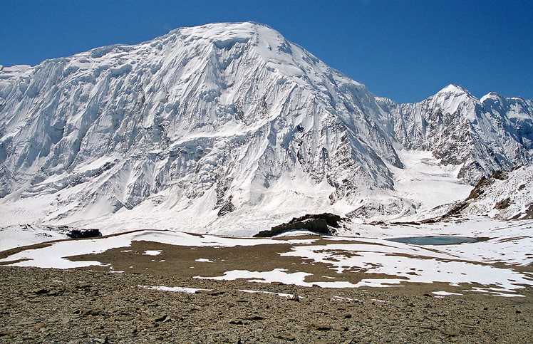
 Tilicho Peak
Weather Forecast, NepalIssued: 10 am Sun 14 Dec Local TimeUpdates in: hr min sUpdate imminent
Issued: 10 am Sun 14 Dec Local Time
Updates in:
Update imminent hr min s

Issued: 10 am Sun 14 Dec Local Time
Updates in:
Update imminent hr min s
Days 1–3 Weather SummaryMostly dry. Extremely cold (max -16°C on Tue morning, min -18°C on Sun morning). Winds increasing (moderate winds from the WNW on Sun night, near gales from the WNW by Tue morning). | Days 4–6 Weather SummaryMostly dry. Extremely cold (max -13°C on Fri morning, min -16°C on Wed morning). Winds increasing (fresh winds from the NW on Wed afternoon, near gales from the NW by Fri night). | |||||||||||||||||
Sunday 14 | Monday 15 | Tuesday 16 | Wednesday 17 | Thursday 18 | Friday 19 | |||||||||||||
AM | PM | night | AM | PM | night | AM | PM | night | AM | PM | night | AM | PM | night | AM | PM | night | |
clear | clear | clear | clear | clear | clear | clear | clear | clear | clear | clear | clear | clear | clear | clear | clear | clear | clear | |
km/h | ||||||||||||||||||
 |  |  |  |  |  | |||||||||||||
— | — | — | — | — | — | — | — | — | — | — | — | — | — | — | — | — | — | |
— | — | — | — | — | — | — | — | — | — | — | — | — | — | — | — | — | — | |
max°C | -18 | -18 | -18 | -17 | -18 | -17 | -16 | -16 | -17 | -15 | -15 | -15 | -14 | -14 | -14 | -13 | -13 | -14 |
min°C | -18 | -18 | -18 | -18 | -18 | -18 | -16 | -17 | -18 | -16 | -15 | -15 | -15 | -15 | -14 | -14 | -14 | -14 |
-31 | -32 | -32 | -31 | -31 | -33 | -31 | -32 | -33 | -30 | -28 | -27 | -28 | -28 | -27 | -27 | -27 | -28 | |
3950 | 3550 | 3300 | 4050 | 3700 | 3350 | 4100 | 3700 | 3750 | 4400 | 4000 | 3800 | 4450 | 4100 | 3950 | 4550 | 4150 | 4100 | |
Cloud base (m) | 8950 | |||||||||||||||||
6:54 | — | — | 6:54 | — | — | 6:54 | — | — | 6:56 | — | — | 6:56 | — | — | 6:56 | — | — | |
— | 5:14 | — | — | 5:14 | — | — | 5:15 | — | — | 5:15 | — | — | 5:15 | — | — | 5:15 | — | |
Loading...
Tilicho Peak Weather (Days 0-3):
The weather forecast for Tilicho Peak is: Mostly dry. Extremely cold (max -16°C on Tue morning, min -18°C on Sun morning). Winds increasing (moderate winds from the WNW on Sun night, near gales from the WNW by Tue morning).
Tilicho Peak Weather (Days 3-6):
Mostly dry. Extremely cold (max -13°C on Fri morning, min -16°C on Wed morning). Winds increasing (fresh winds from the NW on Wed afternoon, near gales from the NW by Fri night).
This table gives the weather forecast for Tilicho Peak at the specific elevation of 6500 m. Our advanced weather models allow us to provide distinct weather forecasts for several elevations of Tilicho Peak. To see the weather forecasts for the other elevations, use the tab navigation above the table. For a wider overview of the weather, consult the Weather Map of Nepal.
| Weather Station | Temp. | Weather | Wind | Gusts | Cloud / Visibility |
|---|---|---|---|---|---|
Tingri | |||||
Fursatganj Airport | |||||
Pakyong Airport- Pakyong | |||||
* NOTE: not all weather observatories update at the same frequency which is the reason why some locations may show data from stations that are further away than known closer ones.
Tilicho Peak Photos
View all
Annapurna Himal photos (20) |
Greater Himalaya photos (318) |
photos from mountains in Nepal (247) |
all photos
 Upload new photo
Tilicho Peak