
– Lat/Long: 62.48° N 7.74° E
 Trollryggen
Weather Forecast, NorwayIssued: 7 am Mon 28 Apr Local TimeUpdates in: hr min sUpdate imminent
Trollryggen Weather Forecast, Norway
Issued: 7 am Mon 28 Apr Local Time
Updates in:
Update imminent hr min s

Issued: 7 am Mon 28 Apr Local Time
Updates in:
Update imminent hr min s
Days 1–3 Weather SummaryHeavy rain (total 24mm), mostly on Mon morning. Becoming colder with a light covering of snow ,mostly falling on Tue night. Freeze-thaw conditions (max 5°C on Wed night, min -1°C on Tue night). Wind will be generally light. | Days 4–6 Weather SummaryLight rain (total 7mm) on Thu afternoon. Becoming colder with heavy fall of snow, heaviest during Fri morning. Freeze-thaw conditions (max 7°C on Thu morning, min -4°C on Sat night). Winds increasing (light winds from the SW on Thu night, fresh winds from the W by Fri night). | |||||||||||||||||
Monday 28 | Tuesday 29 | Wednesday 30 | Thursday 1 | Friday 2 | Saturday 3 | |||||||||||||
AM | PM | night | AM | PM | night | AM | PM | night | AM | PM | night | AM | PM | night | AM | PM | night | |
heavy rain | light snow | light snow | cloudy | light rain | snow shwrs | some clouds | cloudy | heavy rain | light rain | rain shwrs | snow shwrs | heavy snow | light snow | light snow | light snow | light snow | light snow | |
km/h | ||||||||||||||||||
 |  |  |  |  |  | |||||||||||||
— | 1.0 | 1.0 | — | — | 3 | — | — | — | — | — | 5 | 11 | 1.0 | 4 | 4 | 2.0 | 1.0 | |
11 | 0.4 | 0.4 | — | 2.0 | — | — | — | 10 | 1.0 | 4 | 1.8 | — | — | — | — | — | — | |
max°C | 3 | 2 | 2 | 1 | 2 | 2 | 1 | 3 | 5 | 7 | 4 | 3 | -1 | 0 | 0 | -3 | -2 | -2 |
min°C | 3 | 2 | 1 | 1 | 2 | -1 | 0 | 3 | 3 | 5 | 4 | -1 | -1 | 0 | 0 | -3 | -2 | -4 |
0 | -1 | -3 | -2 | -1 | -5 | -3 | 1 | 0 | 2 | 1 | -5 | -6 | -4 | -4 | -9 | -7 | -8 | |
1450 | 1300 | 1200 | 1200 | 1400 | 950 | 1150 | 1400 | 1900 | 1800 | 1550 | 1000 | 800 | 1050 | 1050 | 650 | 750 | 250 | |
Cloud base (m) | 550 | 550 | 700 | 550 | 550 | 600 | 800 | 2400 | 550 | 1700 | 500 | 700 | 550 | 550 | 500 | 550 | 550 | 550 |
5:24 | — | — | 5:20 | — | — | 5:16 | — | — | 5:13 | — | — | 5:11 | — | — | 5:07 | — | — | |
— | — | 9:30 | — | — | 9:34 | — | — | 9:36 | — | — | 9:38 | — | — | 9:42 | — | — | 9:45 | |
Loading...
Trollryggen Weather (Days 0-3):
The weather forecast for Trollryggen is: Heavy rain (total 24mm), mostly on Mon morning. Becoming colder with a light covering of snow ,mostly falling on Tue night. Freeze-thaw conditions (max 5°C on Wed night, min -1°C on Tue night). Wind will be generally light.
Trollryggen Weather (Days 3-6):
Light rain (total 7mm) on Thu afternoon. Becoming colder with heavy fall of snow, heaviest during Fri morning. Freeze-thaw conditions (max 7°C on Thu morning, min -4°C on Sat night). Winds increasing (light winds from the SW on Thu night, fresh winds from the W by Fri night).
This table gives the weather forecast for Trollryggen at the specific elevation of 1000 m. Our advanced weather models allow us to provide distinct weather forecasts for several elevations of Trollryggen. To see the weather forecasts for the other elevations, use the tab navigation above the table. For a wider overview of the weather, consult the Weather Map of Norway.
| Weather Station | Temp. | Weather | Wind | Gusts | Cloud / Visibility |
|---|---|---|---|---|---|
Marstein | |||||
Romsdalsgondolen Fje | |||||
Bjorli Skisenter AS | |||||
Bjorli | |||||
Vestnes KRIK | |||||
Malmefjorden- ener'n | |||||
* NOTE: not all weather observatories update at the same frequency which is the reason why some locations may show data from stations that are further away than known closer ones.
Trollryggen Photos
View all
Scandinavia/European Arctic Ranges photos (14) |
photos from mountains in Norway (113) |
all photos
 Upload new photo
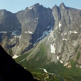
Trollryggen

