
– Lat/Long: 42.26° N 80.89° E
 Xuelian Feng, Xuelian Peak or Snow Lotus Peak
Weather Forecast, ChinaIssued: 5 pm Sat 19 Apr Local TimeUpdates in: hr min sUpdate imminent
Xuelian Feng, Xuelian Peak or Snow Lotus Peak Weather Forecast, China
Issued: 5 pm Sat 19 Apr Local Time
Updates in:
Update imminent hr min s

Issued: 5 pm Sat 19 Apr Local Time
Updates in:
Update imminent hr min s
Days 1–4 Weather SummaryA dusting of new snow. Extremely cold (max -23°C on Mon afternoon, min -30°C on Sat night). Winds decreasing (stormy winds from the W on Sat night, light winds from the SW by Mon night). | Days 5–7 Weather SummaryA heavy fall of snow, heaviest during Tue night. Extremely cold (max -24°C on Tue afternoon, min -30°C on Wed night). Winds increasing (calm on Wed morning, strong winds from the WNW by Thu night). | ||||||||||||||||
Sat 19 | Sunday 20 | Monday 21 | Tuesday 22 | Wednesday 23 | Thursday 24 | ||||||||||||
PM | night | AM | PM | night | AM | PM | night | AM | PM | night | AM | PM | night | AM | PM | night | |
light snow | snow shwrs | clear | clear | some clouds | clear | some clouds | some clouds | some clouds | light snow | heavy snow | mod. snow | snow shwrs | some clouds | snow shwrs | snow shwrs | some clouds | |
km/h | |||||||||||||||||
 |  |  |  |  |  | ||||||||||||
1.0 | 1.0 | — | — | — | — | — | — | — | 3 | 14 | 7 | 9 | — | 1.0 | 3 | — | |
— | — | — | — | — | — | — | — | — | — | — | — | — | — | — | — | — | |
max°C | -27 | -28 | -29 | -27 | -26 | -24 | -23 | -24 | -24 | -24 | -25 | -26 | -26 | -28 | -29 | -28 | -29 |
min°C | -27 | -30 | -30 | -28 | -27 | -25 | -24 | -25 | -24 | -24 | -27 | -27 | -27 | -30 | -29 | -28 | -29 |
-48 | -53 | -51 | -45 | -42 | -41 | -37 | -35 | -34 | -37 | -39 | -27 | -41 | -42 | -38 | -43 | -45 | |
2950 | 2150 | 2050 | 2600 | 1850 | 2500 | 3150 | 2250 | 2950 | 3400 | 2850 | 2950 | 3000 | 2250 | 2650 | 3050 | 1800 | |
Cloud base (m) | 4650 | 4650 | 8100 | 8600 | 4600 | 4650 | 6550 | 8300 | 4700 | 4550 | 4550 | 4550 | 4550 | 4600 | 4950 | 4550 | |
— | — | 5:48 | — | — | 5:46 | — | — | 5:45 | — | — | 5:43 | — | — | 5:41 | — | — | |
7:21 | — | — | 7:22 | — | — | 7:23 | — | — | 7:24 | — | — | 7:25 | — | — | 7:27 | — | |
Loading...
Xuelian Feng, Xuelian Peak or Snow Lotus Peak Weather (Days 0-3):
The weather forecast for Xuelian Feng, Xuelian Peak or Snow Lotus Peak is: A dusting of new snow. Extremely cold (max -23°C on Mon afternoon, min -30°C on Sat night). Winds decreasing (stormy winds from the W on Sat night, light winds from the SW by Mon night).
Xuelian Feng, Xuelian Peak or Snow Lotus Peak Weather (Days 3-6):
A heavy fall of snow, heaviest during Tue night. Extremely cold (max -24°C on Tue afternoon, min -30°C on Wed night). Winds increasing (calm on Wed morning, strong winds from the WNW by Thu night).
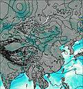
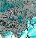
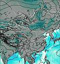
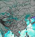
This table gives the weather forecast for Xuelian Feng, Xuelian Peak or Snow Lotus Peak at the specific elevation of 6627 m. Our advanced weather models allow us to provide distinct weather forecasts for several elevations of Xuelian Feng, Xuelian Peak or Snow Lotus Peak. To see the weather forecasts for the other elevations, use the tab navigation above the table. For a wider overview of the weather, consult the Weather Map of China.

