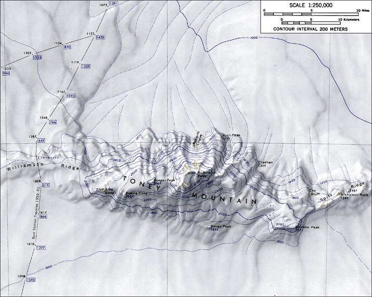
– Lat/Long: 75.73° S 115.67° W
 Zurn Peak
Weather Forecast, AntarcticaIssued: 11 pm Sat 19 Apr Local TimeUpdates in: hr min sUpdate imminent
Zurn Peak Weather Forecast, Antarctica
Issued: 11 pm Sat 19 Apr Local Time
Updates in:
Update imminent hr min s

Issued: 11 pm Sat 19 Apr Local Time
Updates in:
Update imminent hr min s
Days 1–4 Weather SummaryA moderate fall of snow, heaviest on Tue morning. Extremely cold (max -14°C on Tue morning, min -23°C on Sat night). Winds increasing (light winds from the SE on Sat night, strong winds from the SSE by Mon night). | Days 5–7 Weather SummaryA heavy fall of snow, heaviest during Thu night. Extremely cold (max -15°C on Wed night, min -21°C on Tue night). Winds increasing (light winds from the SE on Thu morning, fresh winds from the E by Thu night). | ||||||||||||||||||
Sunday 20 | Monday 21 | Tuesday 22 | Wednesday 23 | Thursday 24 | Friday 25 | ||||||||||||||
night | AM | PM | night | AM | PM | night | AM | PM | night | AM | PM | night | AM | PM | night | AM | PM | night | |
some clouds | cloudy | cloudy | light snow | some clouds | some clouds | light snow | light snow | light snow | snow shwrs | cloudy | light snow | snow shwrs | cloudy | cloudy | mod. snow | light snow | light snow | light snow | |
km/h | |||||||||||||||||||
 |  |  |  |  |  |  | |||||||||||||
— | — | — | 3 | — | — | 3 | 5 | 3 | 1.0 | — | 3 | 2.0 | — | — | 8 | 4 | 2.0 | 1.0 | |
— | — | — | — | — | — | — | — | — | — | — | — | — | — | — | — | — | — | — | |
max°C | -21 | -22 | -21 | -20 | -20 | -21 | -15 | -14 | -15 | -16 | -18 | -16 | -15 | -19 | -19 | -17 | -17 | -18 | -20 |
min°C | -23 | -23 | -23 | -21 | -21 | -21 | -19 | -15 | -15 | -21 | -21 | -18 | -20 | -20 | -20 | -18 | -17 | -19 | -22 |
-31 | -32 | -32 | -30 | -32 | -33 | -33 | -26 | -27 | -32 | -34 | -30 | -30 | -29 | -31 | -30 | -28 | -29 | -32 | |
0 | 0 | 0 | 0 | 0 | 0 | 0 | 0 | 0 | 0 | 0 | 0 | 0 | 0 | 0 | 0 | 0 | 0 | 0 | |
Cloud base (m) | 2200 | 1800 | 1800 | 1800 | 1750 | 1750 | 1800 | 1800 | 1800 | 1800 | 1800 | 1800 | 1800 | 1800 | 1800 | 1800 | 1800 | 1800 | |
— | 4:43 | — | — | 4:52 | — | — | 5:01 | — | — | 5:09 | — | — | 5:18 | — | — | 5:28 | — | — | |
— | — | — | 10:36 | — | — | 10:27 | — | — | 10:18 | — | — | 10:10 | — | — | 10:00 | — | — | 9:51 | |
Loading...
Zurn Peak Weather (Days 0-3):
The weather forecast for Zurn Peak is: A moderate fall of snow, heaviest on Tue morning. Extremely cold (max -14°C on Tue morning, min -23°C on Sat night). Winds increasing (light winds from the SE on Sat night, strong winds from the SSE by Mon night).
Zurn Peak Weather (Days 3-6):
A heavy fall of snow, heaviest during Thu night. Extremely cold (max -15°C on Wed night, min -21°C on Tue night). Winds increasing (light winds from the SE on Thu morning, fresh winds from the E by Thu night).
This table gives the weather forecast for Zurn Peak at the specific elevation of 1515 m. Our advanced weather models allow us to provide distinct weather forecasts for several elevations of Zurn Peak. To see the weather forecasts for the other elevations, use the tab navigation above the table. For a wider overview of the weather, consult the Weather Map of Antarctica.
Zurn Peak Photos
View all
Antarctica Ranges photos (2) |
photos from mountains in Antarctica (37) |
all photos
 Upload new photo
Zurn Peak

