– Lat/Long: 44.96° N 6.22° E
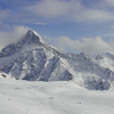
 Aiguille du Plat de la Selle
Weather Forecast, FranceIssued: 12 pm Sun 14 Dec Local TimeUpdates in: hr min sUpdate imminent
Issued: 12 pm Sun 14 Dec Local Time
Updates in:
Update imminent hr min s

Issued: 12 pm Sun 14 Dec Local Time
Updates in:
Update imminent hr min s
Days 1–3 Weather SummaryA dusting of new snow. Freeze-thaw conditions (max 4°C on Sun morning, min -1°C on Mon night). Wind will be generally light. | Days 4–6 Weather SummaryMostly dry. Freeze-thaw conditions (max 3°C on Thu morning, min -1°C on Wed night). Wind will be generally light. | |||||||||||||||||
Sunday 14 | Monday 15 | Tuesday 16 | Wednesday 17 | Thursday 18 | Friday 19 | |||||||||||||
AM | PM | night | AM | PM | night | AM | PM | night | AM | PM | night | AM | PM | night | AM | PM | night | |
clear | clear | clear | some clouds | cloudy | light snow | light snow | cloudy | some clouds | some clouds | some clouds | clear | clear | clear | some clouds | light rain | some clouds | some clouds | |
km/h | ||||||||||||||||||
 |  |  |  |  |  | |||||||||||||
— | — | — | — | — | 2 | 1 | — | — | — | — | — | — | — | — | — | — | — | |
— | — | — | — | — | — | — | — | — | — | — | — | — | — | — | 0.9 | — | — | |
max°C | 4 | 2 | 0 | 3 | 1 | 0 | 1 | 0 | 0 | 2 | 1 | 0 | 3 | 2 | 2 | 3 | 3 | 1 |
min°C | 3 | 0 | 0 | 2 | 0 | -1 | 0 | 0 | -1 | 1 | 0 | -1 | 2 | 0 | 0 | 3 | 1 | 1 |
2 | -3 | -3 | -1 | -4 | -5 | -4 | -3 | -3 | 1 | -2 | -3 | 0 | -4 | -4 | 1 | -2 | -1 | |
2650 | 2600 | 2100 | 2350 | 2250 | 1700 | 1900 | 2100 | 1900 | 2200 | 2200 | 1800 | 2400 | 2500 | 2050 | 2500 | 2550 | 2350 | |
Cloud base (m) | 5850 | 3550 | 2750 | 2400 | 2300 | 2500 | 2650 | 2750 | 2550 | 2650 | 2650 | 2300 | 2300 | 2350 | 2300 | |||
8:04 | — | — | 8:06 | — | — | 8:06 | — | — | 8:07 | — | — | 8:07 | — | — | 8:07 | — | — | |
— | 4:52 | — | — | 4:53 | — | — | 4:53 | — | — | 4:53 | — | — | 4:54 | — | — | 4:54 | — | |
Loading...
Aiguille du Plat de la Selle Weather (Days 0-3):
The weather forecast for Aiguille du Plat de la Selle is: A dusting of new snow. Freeze-thaw conditions (max 4°C on Sun morning, min -1°C on Mon night). Wind will be generally light.
Aiguille du Plat de la Selle Weather (Days 3-6):
Mostly dry. Freeze-thaw conditions (max 3°C on Thu morning, min -1°C on Wed night). Wind will be generally light.
This table gives the weather forecast for Aiguille du Plat de la Selle at the specific elevation of 2000 m. Our advanced weather models allow us to provide distinct weather forecasts for several elevations of Aiguille du Plat de la Selle. To see the weather forecasts for the other elevations, use the tab navigation above the table. For a wider overview of the weather, consult the Weather Map of France.
Aiguille du Plat de la Selle Photos
View all
Dauphine Alps photos (34) |
Alps photos (1480) |
photos from mountains in France (298) |
all photos
 Upload new photo
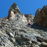
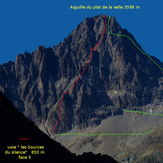
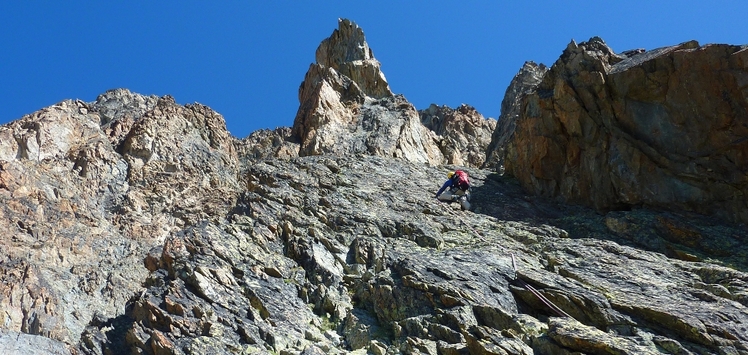
Aiguille du plat de la selle lg 24 "Les sources du silence" malain
Aiguille du plat de la selle face S "Les sources du silence" by malain
Aiguille du Plat de la Selle