– Lat/Long: 44.96° N 6.22° E
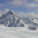
 Aiguille du Plat de la Selle
Weather Forecast, FranceIssued: 1 am Thu 24 Apr Local TimeUpdates in: hr min sUpdate imminent
Aiguille du Plat de la Selle Weather Forecast, France
Issued: 1 am Thu 24 Apr Local Time
Updates in:
Update imminent hr min s

Issued: 1 am Thu 24 Apr Local Time
Updates in:
Update imminent hr min s
Days 1–3 Weather SummaryA heavy fall of snow, heaviest during Sat night. Temperatures will be below freezing (max -3°C on Fri night, min -8°C on Sat night). Winds decreasing (fresh winds from the NNW on Thu morning, calm by Sat night). | Days 4–6 Weather SummaryA moderate fall of snow, heaviest on Sun afternoon. Temperatures will be below freezing (max -3°C on Tue afternoon, min -8°C on Sun morning). Wind will be generally light. | |||||||||||||||||
Thursday 24 | Friday 25 | Saturday 26 | Sunday 27 | Monday 28 | Tuesday 29 | |||||||||||||
AM | PM | night | AM | PM | night | AM | PM | night | AM | PM | night | AM | PM | night | AM | PM | night | |
clear | clear | clear | clear | clear | clear | clear | light snow | heavy snow | cloudy | light snow | snow shwrs | clear | snow shwrs | snow shwrs | clear | some clouds | snow shwrs | |
km/h | ||||||||||||||||||
 |  |  |  |  |  | |||||||||||||
— | — | — | — | — | — | — | 1.0 | 21 | — | 4 | 2.0 | — | 1.0 | 2.0 | — | — | 1.0 | |
— | — | — | — | — | — | — | — | — | — | — | — | — | — | — | — | — | — | |
max°C | -6 | -6 | -5 | -5 | -5 | -3 | -6 | -5 | -6 | -8 | -8 | -7 | -7 | -6 | -4 | -4 | -3 | -3 |
min°C | -7 | -7 | -6 | -5 | -5 | -5 | -6 | -6 | -8 | -8 | -8 | -8 | -7 | -7 | -6 | -4 | -4 | -4 |
-16 | -15 | -14 | -13 | -12 | -10 | -11 | -11 | -12 | -12 | -8 | -11 | -11 | -10 | -10 | -8 | -6 | -7 | |
2450 | 2550 | 2500 | 2700 | 2900 | 3050 | 2700 | 2700 | 2400 | 2450 | 2500 | 2350 | 2600 | 2750 | 2850 | 3050 | 3150 | 3150 | |
Cloud base (m) | 2300 | 2400 | 2300 | 2650 | 9100 | 2600 | 2750 | 2300 | 2300 | 2300 | 2350 | 2400 | 2700 | 2850 | 9300 | 3450 | 2550 | |
6:35 | — | — | 6:33 | — | — | 6:33 | — | — | 6:31 | — | — | 6:30 | — | — | 6:28 | — | — | |
— | — | 8:30 | — | — | 8:31 | — | — | 8:32 | — | — | 8:34 | — | — | 8:36 | — | — | 8:37 | |
Loading...
Aiguille du Plat de la Selle Weather (Days 0-3):
The weather forecast for Aiguille du Plat de la Selle is: A heavy fall of snow, heaviest during Sat night. Temperatures will be below freezing (max -3°C on Fri night, min -8°C on Sat night). Winds decreasing (fresh winds from the NNW on Thu morning, calm by Sat night).
Aiguille du Plat de la Selle Weather (Days 3-6):
A moderate fall of snow, heaviest on Sun afternoon. Temperatures will be below freezing (max -3°C on Tue afternoon, min -8°C on Sun morning). Wind will be generally light.
This table gives the weather forecast for Aiguille du Plat de la Selle at the specific elevation of 3596 m. Our advanced weather models allow us to provide distinct weather forecasts for several elevations of Aiguille du Plat de la Selle. To see the weather forecasts for the other elevations, use the tab navigation above the table. For a wider overview of the weather, consult the Weather Map of France.
Aiguille du Plat de la Selle Photos
View all
Dauphine Alps photos (34) |
Alps photos (1456) |
photos from mountains in France (280) |
all photos
 Upload new photo
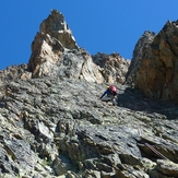
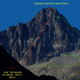
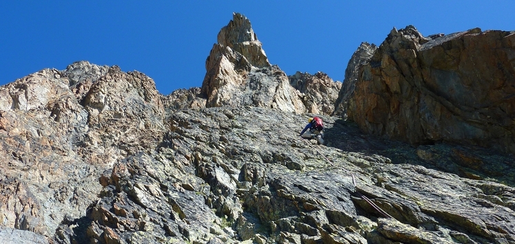
Aiguille du plat de la selle lg 24 "Les sources du silence" malain
Aiguille du plat de la selle face S "Les sources du silence" by malain
Aiguille du Plat de la Selle

