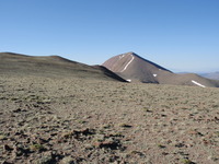
Arc Dome guide
- Elevation: 3589 m
- Difficulty: Walk up
- Best months to climb: June, July, August, September, October
- Convenient center: Round Mountain, Nevada
Arc Dome Climbing Notes
Tom G from UNITED STATES writes:
There are two routes to Arc Dome I chose Stewart Creek Trail. The other tail is a jeep trail on which I returned.
The first forest is an Aspen forest and a lot of trees were marked. Some carvings dated back to 1923.
Then it was a steep climb through Aspen, through Bristlecone, and then through scrubs trees eventually to a small saddle. Unfortunately after the saddle you drop back into a valley and give up 600 feet of elevation before climbing again. After regaining the elevation you finally get to the high plateau. You give up another 600 feet of elevation before the steep 28 switchbacks to the summit
The benefit of the jeep trail is not giving up elevation, but the detriment is walking in all sage and open terrain (I got pretty sunburned in the face). However, there are some great views of Aspen valleys below on this route.
2014-07-06 |
Click here to submit your own climbing note for Arc Dome
|

Select Arc Dome Location Map Detail:
Use this relief map to navigate to mountain peaks in the area of Arc Dome.
10 other mountain peaks closest to Arc Dome:


 Like us
 Follow us
 Follow us