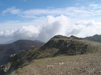
Montseny is technically a range (region & park) rather than one mountain, though it contains the peaks Turo de l'Home (Hill of the man) (1,712 m), Les Agudes (1,706 m), El Matagals (1,697.9 m) and Puig Drau (1,344 m).
Turo de l'Home is accessible to all being serviced by a (controlled) mountain road to the meteorological station near the peak. The whole area is a walker and mountain biker's paradise. On cold January mornings the air can be still enough to see the Balearic Islands from peaks, and is a great early morning CC ski with sufficient snow. The lower mountain rural restaurants and area around them can get busy particularly midday on summer and autumn weekends.
Most popular routes are GR 5 and GR-C 5. and will take a good 4 hours for the moderately fit from town to peak, with pole useful on higher sections. Routes are generally well defined (colour coded and signposted). See links for more routes. It's most easily accessed from Barcelona via Sant Celoni rail station and local park buses.
trekpyrenees com montseny natural park
turisme montseny
wikiloc montseny
Bus:
barcelonabus
Stops in the municipalities of Aiguafreda, Cànoves and Samalús, El Figaró, La Garriga, Tagamanent, Gualba, Sant Celoni, Campins, Fogars de Montclús, Santa Fe, Santa M. de Palautordera, Sant Esteve de Palautordera and Viladrau.


 Like us
 Follow us
 Follow us