– Lat/Long: 42.00° S 173.66° E
 Mt Tapuaenuku (Kaikouras)
Weather Forecast, New ZealandIssued: 12 am Tue 01 Apr Local TimeUpdates in: hr min sUpdate imminent
Mt Tapuaenuku (Kaikouras) Weather Forecast, New Zealand
Issued: 12 am Tue 01 Apr Local Time
Updates in:
Update imminent hr min s

Issued: 12 am Tue 01 Apr Local Time
Updates in:
Update imminent hr min s
Days 1–4 Weather SummaryA dusting of snow turning to light rain (total 4mm) on Wed night. Freeze-thaw conditions (max 4°C on Thu morning, min -1°C on Wed morning). Winds increasing (calm on Mon night, severe gales from the NNW by Thu afternoon). | Days 5–7 Weather SummaryModerate rain (total 13mm) heaviest on Thu night, then becoming colder with a dusting of snow on Fri night. Freeze-thaw conditions (max 4°C on Thu night, min -3°C on Sun afternoon). Winds decreasing (severe gales from the NW on Thu night, light winds from the W by Fri night). | Days 8–10 Weather SummaryA light covering of new snow mostly falling on Tue afternoon. Temperatures will be below freezing (max 0°C on Mon night, min -4°C on Sun night). Winds increasing (calm on Sun night, extremely windy from the NNW by Tue afternoon). | Days 11–13 Weather SummaryA heavy fall of snow, heaviest during Sat afternoon. Freeze-thaw conditions (max 3°C on Thu morning, min -7°C on Sat afternoon). Winds decreasing (stormy winds from the NW on Thu night, light winds from the ESE by Sat morning). | |||||||||||||||||||||||||||||||||
Tuesday 1 | Wednesday 2 | Thursday 3 | Friday 4 | Saturday 5 | Sunday 6 | Monday 7 | Tuesday 8 | Wednesday 9 | Thursday 10 | Friday 11 | Sat 12 | |||||||||||||||||||||||||
night | AM | PM | night | AM | PM | night | AM | PM | night | AM | PM | night | AM | PM | night | AM | PM | night | AM | PM | night | AM | PM | night | AM | PM | night | AM | PM | night | AM | PM | night | AM | PM | |
cloudy | some clouds | cloudy | some clouds | cloudy | cloudy | light snow | light rain | light rain | heavy rain | rain shwrs | rain shwrs | snow shwrs | some clouds | clear | some clouds | cloudy | cloudy | clear | clear | clear | clear | some clouds | snow shwrs | clear | snow shwrs | snow shwrs | clear | some clouds | some clouds | clear | clear | clear | snow shwrs | heavy snow | heavy snow | |
km/h | ||||||||||||||||||||||||||||||||||||
 |  |  |  |  |  |  |  |  |  |  |  |  | ||||||||||||||||||||||||
— | — | — | — | — | — | 1.0 | — | — | — | — | — | 1.0 | — | — | — | — | — | — | — | — | — | — | 3 | — | 1.0 | 3 | — | — | — | — | — | — | 3 | 11 | 34 | |
— | — | — | — | — | — | 3 | 0.1 | 1.8 | 12 | 0.6 | 0.3 | — | — | — | — | — | — | — | — | — | — | — | — | — | — | — | — | — | — | — | — | — | — | — | — | |
max°C | 3 | 1 | 1 | 0 | -1 | 1 | 2 | 4 | 2 | 4 | 4 | 4 | 2 | -2 | 0 | 3 | 1 | -2 | -3 | -2 | -2 | 0 | 0 | 0 | -2 | -3 | -3 | 2 | 3 | 3 | 2 | 0 | -1 | -4 | -6 | -6 |
min°C | 2 | 1 | 0 | 0 | -1 | -1 | 1 | 3 | 2 | 3 | 4 | 4 | -2 | -2 | -1 | 2 | 0 | -3 | -4 | -3 | -3 | -1 | 0 | -2 | -4 | -4 | -4 | -1 | 3 | 2 | -1 | 0 | -2 | -6 | -6 | -7 |
0 | 1 | -3 | -4 | -7 | -8 | -5 | -4 | -6 | -5 | -2 | -2 | -7 | -7 | -7 | -2 | -7 | -12 | -11 | -7 | -9 | -6 | -7 | -13 | -14 | -14 | -13 | -9 | -3 | -5 | -11 | -10 | -12 | -14 | -13 | -18 | |
3400 | 3100 | 3000 | 2900 | 2750 | 2800 | 3150 | 3550 | 3400 | 3550 | 3550 | 3650 | 3050 | 2400 | 2650 | 3300 | 3000 | 2550 | 2300 | 2400 | 2550 | 2700 | 2850 | 2850 | 2500 | 2300 | 2400 | 2850 | 3350 | 3350 | 3200 | 2900 | 2700 | 2100 | 1650 | 1650 | |
Cloud base (m) | 6250 | 6000 | 850 | 650 | 600 | 2050 | 950 | 850 | 800 | 500 | 850 | 500 | 500 | 1450 | 550 | 7050 | 1650 | 2150 | 2250 | 8300 | 750 | 1900 | 550 | 8000 | 6050 | 1600 | 500 | 550 | ||||||||
— | 7:39 | — | — | 7:41 | — | — | 7:41 | — | — | 7:43 | — | — | 7:45 | — | — | 6:46 | — | — | 7:47 | — | — | 7:48 | — | — | 7:48 | — | — | 7:50 | — | — | 7:50 | — | — | 7:52 | — | |
— | — | 7:16 | — | — | 7:15 | — | — | 7:13 | — | — | 7:12 | — | — | 7:09 | — | — | 6:07 | — | — | 7:07 | — | — | 7:05 | — | — | 7:04 | — | — | 7:01 | — | — | 7:00 | — | — | 6:59 | |
Mt Tapuaenuku (Kaikouras) Weather (Days 0-3):
The weather forecast for Mt Tapuaenuku (Kaikouras) is: A dusting of snow turning to light rain (total 4mm) on Wed night. Freeze-thaw conditions (max 4°C on Thu morning, min -1°C on Wed morning). Winds increasing (calm on Mon night, severe gales from the NNW by Thu afternoon).
Mt Tapuaenuku (Kaikouras) Weather (Days 3-6):
Moderate rain (total 13mm) heaviest on Thu night, then becoming colder with a dusting of snow on Fri night. Freeze-thaw conditions (max 4°C on Thu night, min -3°C on Sun afternoon). Winds decreasing (severe gales from the NW on Thu night, light winds from the W by Fri night).
Mt Tapuaenuku (Kaikouras) Weather (Days 6-9):
A light covering of new snow mostly falling on Tue afternoon. Temperatures will be below freezing (max 0°C on Mon night, min -4°C on Sun night). Winds increasing (calm on Sun night, extremely windy from the NNW by Tue afternoon).
This table gives the weather forecast for Mt Tapuaenuku (Kaikouras) at the specific elevation of 2885 m. Our advanced weather models allow us to provide distinct weather forecasts for several elevations of Mt Tapuaenuku (Kaikouras). To see the weather forecasts for the other elevations, use the tab navigation above the table. For a wider overview of the weather, consult the Weather Map of New Zealand.
Mt Tapuaenuku (Kaikouras) Photos
View all
Kaikoura Ranges photos (2) |
New Zealand photos (120) |
photos from mountains in New Zealand (124) |
all photos
 Upload new photo
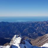
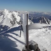
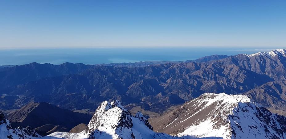
Summit view
Looking down from near top of Mt Tapuaenuku on March 8th 2014
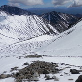
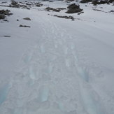
Going Down Mt Tapuaenuku 08.03.14

