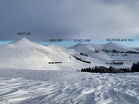
Scald Law guide
- Elevation: 579 m
- Difficulty: Walk up
- Best months to climb: January, February, April, May, June, July, August, September, October, November, December
- Convenient center: Edinburgh
Short but quite steep walk up to the Pentland Hills high point.
Scald Law Climbing Notes
Darren Jeffrey from UNITED KINGDOM writes:
Very accessible. Park at the Flotterstone car park which has toilets and follow the signs.
Over Turnhouse Hill, Carnethy Hill then on to Scald Law. You can carry on to South Black Hill, East Kip and West Kip from here.
Very easy hills to climb in any weather
2012-04-09 |
Click here to submit your own climbing note for Scald Law
|

Select Scald Law Location Map Detail:
Use this relief map to navigate to mountain peaks in the area of Scald Law.
10 other mountain peaks closest to Scald Law:


 Like us
 Follow us
 Follow us