– Lat/Long: 55.84° N 3.29° W
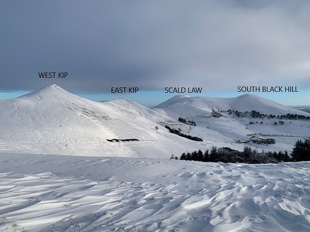
 Scald Law
Weather Forecast, United KingdomIssued: 6 pm Mon 29 Sep Local TimeUpdates in: hr min sUpdate imminent
Issued: 6 pm Mon 29 Sep Local Time
Updates in:
Update imminent hr min s

Issued: 6 pm Mon 29 Sep Local Time
Updates in:
Update imminent hr min s
Days 1–4 Weather SummaryLight rain (total 5mm), mostly falling on Tue night. Very mild (max 13°C on Wed afternoon, min 8°C on Mon afternoon). Winds increasing (light winds from the SSW on Mon afternoon, strong winds from the SSW by Thu morning). | Days 5–7 Weather SummaryHeavy rain (total 28mm), heaviest during Fri night. Very mild (max 11°C on Thu afternoon, min 4°C on Sat afternoon). Winds increasing (moderate winds from the WSW on Fri morning, extremely windy from the WNW by Sat morning). | ||||||||||||||||
Mon 29 | Tuesday 30 | Wednesday 1 | Thursday 2 | Friday 3 | Saturday 4 | ||||||||||||
PM | night | AM | PM | night | AM | PM | night | AM | PM | night | AM | PM | night | AM | PM | night | |
light rain | light rain | some clouds | light rain | light rain | light rain | rain shwrs | light rain | light rain | light rain | rain shwrs | some clouds | light rain | heavy rain | light rain | light rain | light rain | |
km/h | |||||||||||||||||
 |  |  |  |  |  | ||||||||||||
— | — | — | — | — | — | — | — | — | — | — | — | — | — | — | — | — | |
0.6 | 0.5 | — | 0.2 | 2 | 0.7 | 0.3 | 0.5 | 0.2 | 0.1 | 4 | — | 4 | 15 | 1.4 | 1.1 | 1.5 | |
max°C | 8 | 9 | 12 | 12 | 12 | 12 | 13 | 12 | 12 | 11 | 11 | 10 | 9 | 8 | 6 | 4 | 7 |
min°C | 8 | 8 | 10 | 11 | 11 | 12 | 12 | 12 | 12 | 11 | 8 | 9 | 9 | 5 | 5 | 4 | 6 |
6 | 6 | 8 | 8 | 8 | 9 | 9 | 9 | 9 | 7 | 4 | 6 | 5 | -3 | -4 | -5 | -1 | |
2150 | 2450 | 2550 | 2700 | 2850 | 3150 | 3200 | 3300 | 3050 | 2850 | 2550 | 2250 | 2200 | 1400 | 1600 | 1100 | 1650 | |
Cloud base (m) | 1000 | 950 | 350 | 600 | 400 | 250 | 250 | 550 | 400 | 500 | 200 | 500 | 100 | 100 | 100 | 200 | |
— | — | 7:11 | — | — | 7:13 | — | — | 7:16 | — | — | 7:18 | — | — | 7:20 | — | — | |
6:54 | — | — | 6:52 | — | — | 6:50 | — | — | 6:46 | — | — | 6:44 | — | — | 6:42 | — | |
Loading...
Scald Law Weather (Days 0-3):
The weather forecast for Scald Law is: Light rain (total 5mm), mostly falling on Tue night. Very mild (max 13°C on Wed afternoon, min 8°C on Mon afternoon). Winds increasing (light winds from the SSW on Mon afternoon, strong winds from the SSW by Thu morning).
Scald Law Weather (Days 3-6):
Heavy rain (total 28mm), heaviest during Fri night. Very mild (max 11°C on Thu afternoon, min 4°C on Sat afternoon). Winds increasing (moderate winds from the WSW on Fri morning, extremely windy from the WNW by Sat morning).
This table gives the weather forecast for Scald Law at the specific elevation of 579 m. Our advanced weather models allow us to provide distinct weather forecasts for several elevations of Scald Law. To see the weather forecasts for the other elevations, use the tab navigation above the table. For a wider overview of the weather, consult the Weather Map of United Kingdom.
| Weather Station | Temp. | Weather | Wind | Gusts | Cloud / Visibility |
|---|---|---|---|---|---|
Edinburgh Airport | |||||
Broughton | |||||
Tinto | |||||
Witchieknowe |
* NOTE: not all weather observatories update at the same frequency which is the reason why some locations may show data from stations that are further away than known closer ones.
Scald Law Photos
View all
Pentland Hills photos (2) |
Scottish Lowlands photos (31) |
photos from mountains in United Kingdom (2038) |
all photos
 Upload new photo
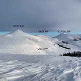
The Pentlands In Winter
Scald Law
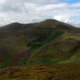
Carnethy wander