
– Lat/Long: 36.96° N 22.35° E
 Taygetos
Weather Forecast, GreeceIssued: 8 pm Tue 30 Sep Local TimeUpdates in: hr min sUpdate imminent
Issued: 8 pm Tue 30 Sep Local Time
Updates in:
Update imminent hr min s

Issued: 8 pm Tue 30 Sep Local Time
Updates in:
Update imminent hr min s
Days 1–4 Weather SummaryHeavy rain (total 77mm), heaviest during Thu morning. Freeze-thaw conditions (max 6°C on Tue night, min -1°C on Fri afternoon). Winds increasing (light winds from the W on Wed night, near gales from the WNW by Fri afternoon). | Days 5–7 Weather SummarySome drizzle, heaviest during Mon afternoon. Freeze-thaw conditions (max 8°C on Sun night, min 0°C on Fri night). Winds decreasing (near gales from the WNW on Fri night, moderate winds from the WNW by Sat night). | ||||||||||||||||||
Wednesday 1 | Thursday 2 | Friday 3 | Saturday 4 | Sunday 5 | Monday 6 | ||||||||||||||
night | AM | PM | night | AM | PM | night | AM | PM | night | AM | PM | night | AM | PM | night | AM | PM | night | |
rain shwrs | clear | rain shwrs | rain shwrs | heavy rain | risk tstorm | risk tstorm | clear | cloudy | some clouds | clear | clear | clear | clear | clear | rain shwrs | clear | rain shwrs | rain shwrs | |
km/h | |||||||||||||||||||
 |  |  |  |  |  |  | |||||||||||||
— | — | — | — | — | — | — | — | — | — | — | — | — | — | — | — | — | — | — | |
0.2 | — | 0.4 | 3 | 43 | 20 | 11 | — | — | — | — | — | — | — | — | 0.3 | — | 1 | 8 | |
max°C | 6 | 5 | 6 | 6 | 6 | 5 | 4 | 1 | 0 | 0 | 2 | 2 | 5 | 6 | 7 | 8 | 8 | 7 | 7 |
min°C | 6 | 5 | 5 | 4 | 5 | 5 | 2 | 1 | -1 | 0 | 2 | 2 | 3 | 5 | 7 | 8 | 8 | 7 | 4 |
2 | 2 | 2 | -1 | -1 | 0 | -5 | -7 | -10 | -8 | -4 | -3 | -2 | 0 | 3 | 4 | 4 | 2 | -2 | |
3500 | 3300 | 3200 | 3300 | 3250 | 3300 | 3050 | 2700 | 2350 | 2450 | 2750 | 2700 | 3350 | 3800 | 4050 | 4400 | 4100 | 3800 | 3400 | |
Cloud base (m) | 750 | 450 | 2550 | 750 | 1450 | 800 | 2450 | 700 | 700 | 2700 | |||||||||
— | 7:24 | — | — | 7:26 | — | — | 7:26 | — | — | 7:26 | — | — | 7:28 | — | — | 7:28 | — | — | |
— | — | 7:14 | — | — | 7:13 | — | — | 7:12 | — | — | 7:09 | — | — | 7:08 | — | — | 7:07 | — | |
Loading...
Taygetos Weather (Days 0-3):
The weather forecast for Taygetos is: Heavy rain (total 77mm), heaviest during Thu morning. Freeze-thaw conditions (max 6°C on Tue night, min -1°C on Fri afternoon). Winds increasing (light winds from the W on Wed night, near gales from the WNW by Fri afternoon).
Taygetos Weather (Days 3-6):
Some drizzle, heaviest during Mon afternoon. Freeze-thaw conditions (max 8°C on Sun night, min 0°C on Fri night). Winds decreasing (near gales from the WNW on Fri night, moderate winds from the WNW by Sat night).
This table gives the weather forecast for Taygetos at the specific elevation of 2407 m. Our advanced weather models allow us to provide distinct weather forecasts for several elevations of Taygetos. To see the weather forecasts for the other elevations, use the tab navigation above the table. For a wider overview of the weather, consult the Weather Map of Greece.
| Weather Station | Temp. | Weather | Wind | Gusts | Cloud / Visibility |
|---|---|---|---|---|---|
Kalamata (Airport) | |||||
Tripolis (Airport) | |||||
Kythira | |||||
Andravida (Airport) |
* NOTE: not all weather observatories update at the same frequency which is the reason why some locations may show data from stations that are further away than known closer ones.
Taygetos Photos
View all
Greek-Albanian Ranges photos (439) |
Balkan Peninsula photos (1024) |
photos from mountains in Greece (664) |
all photos
 Upload new photo
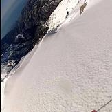

 See 24 more Taygetos photos
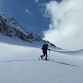
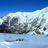
Virgin slopes
road to chalasmeno
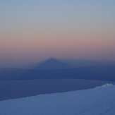
sunrice at the summit!!
Taygetos Mountain
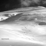
Turning from the top
perfect panorama