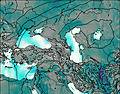
– Lat/Long: 39.00° N 38.00° E
 Vercenik
Weather Forecast, TurkeyIssued: 8 am Tue 01 Apr Local TimeUpdates in: 3hr 6min 24sUpdate imminent
Issued: 8 am Tue 01 Apr Local Time
Updates in:
Update imminent 3hr 6min 24s

Issued: 8 am Tue 01 Apr Local Time
Updates in:
Update imminent 3hr 6min 24s
Days 1–3 Weather SummaryModerate rain (total 14mm) heaviest on Wed afternoon, then becoming colder with a dusting of snow on Thu morning. Mild temperatures (max 7°C on Tue morning, min 1°C on Thu morning). Winds decreasing (near gales from the SE on Tue night, calm by Wed night). | Days 4–6 Weather SummaryModerate rain (total 15mm), heaviest on Sat afternoon. Mild temperatures (max 6°C on Sat afternoon, min 2°C on Fri morning). Mainly fresh winds. | Days 7–9 Weather SummaryModerate rain (total 11mm), heaviest on Tue afternoon. Very mild (max 11°C on Mon afternoon, min 1°C on Wed night). Winds decreasing (strong winds from the SSW on Mon afternoon, light winds from the SSW by Tue night). | Days 10–12 Weather SummaryMild at first with light rain (total 2mm) on Thu afternoon followed by colder weather and light fall of snow, heaviest on Thu night. Freeze-thaw conditions (max 2°C on Thu morning, min -8°C on Thu night). Winds decreasing (fresh winds from the S on Thu morning, light winds from the SW by Sat night). | |||||||||||||||||||||||||||||||||
Tuesday 1 | Wednesday 2 | Thursday 3 | Friday 4 | Saturday 5 | Sunday 6 | Monday 7 | Tuesday 8 | Wednesday 9 | Thursday 10 | Friday 11 | Saturday 12 | |||||||||||||||||||||||||
AM | PM | night | AM | PM | night | AM | PM | night | AM | PM | night | AM | PM | night | AM | PM | night | AM | PM | night | AM | PM | night | AM | PM | night | AM | PM | night | AM | PM | night | AM | PM | night | |
some clouds | cloudy | mod. rain | light rain | light rain | rain shwrs | light snow | rain shwrs | rain shwrs | rain shwrs | light rain | light rain | risk tstorm | risk tstorm | rain shwrs | rain shwrs | light rain | rain shwrs | clear | light rain | rain shwrs | rain shwrs | risk tstorm | rain shwrs | cloudy | rain shwrs | rain shwrs | light snow | light snow | heavy snow | cloudy | some clouds | some clouds | some clouds | some clouds | some clouds | |
mph | ||||||||||||||||||||||||||||||||||||
 |  |  |  |  |  |  |  |  |  |  |  | |||||||||||||||||||||||||
— | — | — | — | — | — | 2 | — | — | — | — | — | — | — | — | — | — | — | — | — | — | — | — | — | — | — | — | 0.4 | 0.4 | 4 | — | — | — | — | — | — | |
— | — | 0.2 | 0.08 | 0.2 | 0.05 | — | 0.03 | 0.00 | 0.02 | 0.06 | 0.2 | 0.07 | 0.1 | 0.01 | 0.00 | 0.08 | 0.04 | — | 0.02 | 0.07 | 0.08 | 0.2 | 0.01 | — | 0.03 | 0.04 | — | 0.09 | — | — | — | — | — | — | — | |
max°F | 45 | 45 | 41 | 37 | 39 | 37 | 34 | 39 | 37 | 39 | 41 | 39 | 41 | 43 | 39 | 39 | 41 | 41 | 46 | 52 | 46 | 46 | 46 | 45 | 41 | 43 | 39 | 36 | 36 | 32 | 19 | 23 | 23 | 28 | 34 | 34 |
min°F | 41 | 43 | 37 | 37 | 39 | 36 | 34 | 37 | 36 | 36 | 41 | 37 | 39 | 41 | 36 | 37 | 37 | 39 | 43 | 48 | 43 | 45 | 46 | 39 | 39 | 43 | 34 | 34 | 36 | 18 | 19 | 21 | 19 | 25 | 32 | 32 |
36 | 34 | 25 | 28 | 32 | 34 | 32 | 34 | 34 | 28 | 34 | 28 | 32 | 34 | 28 | 28 | 28 | 32 | 36 | 41 | 34 | 37 | 41 | 34 | 34 | 37 | 25 | 25 | 25 | 3 | 5 | 7 | 5 | 14 | 25 | 27 | |
9400 | 9200 | 8400 | 8400 | 8200 | 7900 | 7400 | 7900 | 7700 | 7700 | 8500 | 8400 | 8200 | 8500 | 8200 | 8000 | 8000 | 9000 | 9800 | 10700 | 10300 | 10200 | 9800 | 9200 | 8400 | 8700 | 7900 | 7200 | 7700 | 5600 | 3100 | 4300 | 3300 | 4800 | 6400 | 6600 | |
Cloud base (ft) | 22800 | 8400 | 6200 | 6100 | 6100 | 8200 | 6700 | 6100 | 8000 | 7200 | 7500 | 8500 | 6700 | 7700 | 9800 | 7400 | 7100 | 9700 | — | 11600 | 9400 | 9000 | 8200 | — | 8200 | 8700 | 7900 | 7500 | 6100 | 6100 | 6600 | 7100 | 6200 | 6200 | 6700 | 7700 |
6:13 | — | — | 6:11 | — | — | 6:09 | — | — | 6:07 | — | — | 6:05 | — | — | 6:05 | — | — | 6:03 | — | — | 6:01 | — | — | 6:00 | — | — | 5:58 | — | — | 5:56 | — | — | 5:56 | — | — | |
— | 6:51 | — | — | 6:52 | — | — | 6:52 | — | — | 6:53 | — | — | 6:54 | — | — | 6:55 | — | — | 6:57 | — | — | 6:58 | — | — | 6:59 | — | — | 7:00 | — | — | 7:00 | — | — | 7:01 | — | |
Vercenik Weather (Days 0-3):
The weather forecast for Vercenik is: Moderate rain (total 14mm) heaviest on Wed afternoon, then becoming colder with a dusting of snow on Thu morning. Mild temperatures (max 7°C on Tue morning, min 1°C on Thu morning). Winds decreasing (near gales from the SE on Tue night, calm by Wed night).
Vercenik Weather (Days 3-6):
Moderate rain (total 15mm), heaviest on Sat afternoon. Mild temperatures (max 6°C on Sat afternoon, min 2°C on Fri morning). Mainly fresh winds.
Vercenik Weather (Days 6-9):
Moderate rain (total 11mm), heaviest on Tue afternoon. Very mild (max 11°C on Mon afternoon, min 1°C on Wed night). Winds decreasing (strong winds from the SSW on Mon afternoon, light winds from the SSW by Tue night).
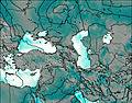
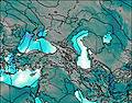
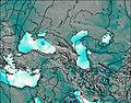
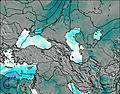
This table gives the weather forecast for Vercenik at the specific elevation of 2000 m. Our advanced weather models allow us to provide distinct weather forecasts for several elevations of Vercenik. To see the weather forecasts for the other elevations, use the tab navigation above the table. For a wider overview of the weather, consult the Weather Map of Turkey.
| Weather Station | Temp. | Weather | Wind | Gusts | Cloud / Visibility |
|---|---|---|---|---|---|
Malaty / rhac | |||||
Tulga Meydan | |||||
Erzincan Merkez | |||||
Erzincan Havalimani |
* NOTE: not all weather observatories update at the same frequency which is the reason why some locations may show data from stations that are further away than known closer ones.
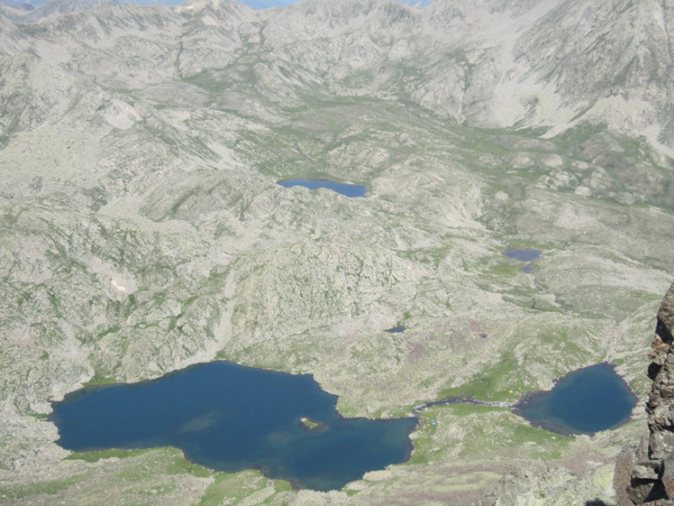
Vercenik Photos
View all
Northern Anatolia (Black Sea) photos (76) |
Anatolia photos (509) |
photos from mountains in Turkey (476) |
all photos
 Upload new photo
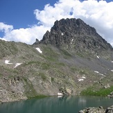

 See 11 more Vercenik photos
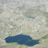
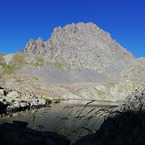
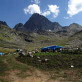
Verçenik and Lakes
Verçenik Lakes
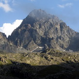
Verçenik
Verçenik
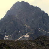
Verçenik
Verçenik

